Background
The National Oceanic and Atmospheric Administration (NOAA) defines storm surge as the abnormal rise in seawater level during a storm, measured as the height of the water above the normal predicted astronomical tide. The surge is caused primarily by storm winds pushing water onshore (NOAA, 2019). The amplitude of a storm surge is attributed to several factors including the orientation of the coastline with respect to the storm track, strength of the storm, local bathymetry, and coastline shape.
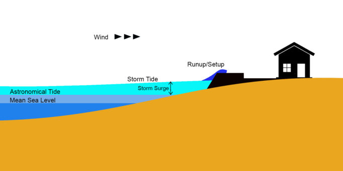
Figure 1. Illustration of Sea Level, Astronomical Tide, and Storm Tide.
Based on the ranking made by NOAA using their International Best Track Archive for Climate Stewardship (IBTrACS) database (NOAA, 2018), the Philippines ranks third in terms of the total number of tropical cyclone hits by country, and ranks second when it comes to the ranking of tropical cyclone hits by country since 1970. Despite the damage received by the Philippines from tropical cyclones yearly, the effects of storm surge have not been given much attention by the Filipino public until Typhoon Haiyan, known as Super Typhoon Yolanda in the Philippines, that occurred in 2013.
Manila Bay is the biggest bay in Luzon Island and is also home to the biggest port in the country. Should a calamity impact the whole country, Manila is in danger of having the highest casualties and largest damage to properties because of its population and location of its infrastructure network.
It is important that the historical storm surge and tide in Manila Bay be studied to understand the behavior of the water movements within the Bay during tropical cyclones. This information is essential for the effective design of reclamation areas including the ground elevation above the sea level, the height of sea walls and the size of breakwaters.
It is important that the historical storm surge and tide in Manila Bay be studied to understand the behavior of the water movements within the Bay during tropical cyclones. This information is essential for the effective design of reclamation areas including the ground elevation above the sea level, the height of sea walls and the size of breakwaters.
The period of 2016-2017 is used in this study as it was the only period where there were three operational tide stations inside the Bay that could provide sufficient records to analyze the effects of cyclone activity in generating storm surges.
National Hydrographic Offices such as the Hydrography Branch of the National Mapping and Resource Information Authority (NAMRIA) primarily measure tide heights to establish and update the vertical datum for navigational charts. However, hydrographic data are increasingly being used in other research fields besides charting purposes. In storm surge analysis, tidal height measurements by hydrographic offices are not just a convenient source of data but are also the most reliable form of its measurement.
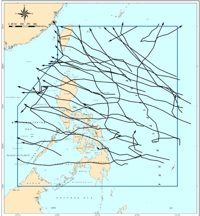
Figure 2. Paths of Tropical Cyclones that passed through the Philippine Area of Responsibility (PAR) in 2016 and 2017.
The height of the storm surge was determined as the residual by subtracting the observed water level from the predicted water level. The Manila South Harbor Tide Station is located in an area where it is sheltered from waves and is able to measure still water. Wave run-up and set-up were already eliminated from the recorded data.
Results
The observed and predicted water level values closely match with each other when there is no weather disturbance. The analysis also showed that there are tropical cyclones that have no obvious impact on water level when passing through the PAR. Tropical cyclones that did not make landfall in Luzon were generally too far away to create significant rise in the water level in Manila Bay.
Out of the 34 tropical cyclones with recorded tide height data in 2016-2017, there were only four (Super Typhoon Lawin, Typhoon Paolo, Tropical Storm Karen, Typhoon Odette) that caused a storm surge of 30 centimeters.
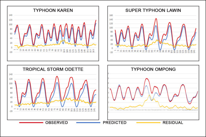
Figure 3. Water level at MSH Station during Tropical Cyclones Karen, Lawin, Odette, and Ompong landfall.
The cyclone that produced the highest storm surge from 2016 t0 2017 was Super Typhoon (STY) Lawin with a highest wind speed of 270 KPH. The other two were Typhoons (TY Paolo and TY Odette) and the last was a Tropical Storm (TS Karen). All made landfall in Luzon and north of Manila Bay except for TY Paolo, which entered the PAR at the same time as TY Odette was exiting the PAR. TY Odette may still have influenced the wind in Manila Bay even though it was outside of the PAR. In comparison, TY Ompong created 50 centimeters of storm surge in 2018, despite having a similar path to the three tropical cyclones that generated storm surges.
The data analysis suggests that the magnitude of a storm surge in Manila Bay can depend on the combination of a tropical cyclone’s sustained winds, distance from Manila Bay, and path. The highest rise in water level was created by tropical cyclones passing and making landfall north of Manila Bay. Tropical cyclones passing north of Manila produce onshore winds when it makes landfall in Luzon, thereby pushing the water towards the coastal area of Manila.
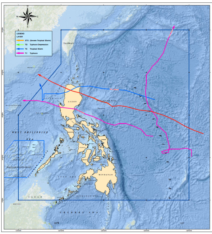
Figure 4. Path of the four Tropical Cyclones that produced the highest storm surge from January 2016 to December 2017.
The observed residuals from the tropical cyclones in the study period are generally smaller than the predicted heights from modeling studies. No tropical cyclone, including the strongest super typhoon, produced more than one meter of residual. TY Ompong produced only 50 centimeters of storm surge. TY Ompong had the ideal wind direction, strength and path to produce a large storm surge. However, it did not create the expected storm surge in Manila Bay compared to the storm surge that TY Haiyan produced in San Pedro Bay.
The shape of Manila Bay may help to prevent the development of large storm surges. In comparison, San Pedro Bay is funnel shaped, is located at the east side of the archipelago and faces the Pacific Ocean. Tropical cyclones normally develop in the east side of the Philippines and travel westward towards mainland Asia. Manila Bay is semi-enclosed and located on the west side of the country. The location and configuration of Manila Bay likely reduces the movement of water that can create larger storm surges.
The study data indicated that floods that occur during tropical cyclones are not caused by storm surge. Seawalls along Manila Bay are generally higher than the recorded storm tide levels. Flooding has been caused by wave run-up and set-up because water was thrown to the other side of the seawall by breaking waves. Floods did not occur because the water level was above the seawalls, rather it was due to the water from breaking waves exceeding the tops of the barriers. It is therefore important to differentiate storm surge, which is sustained over a long period of time from waves, which are generated within short periods.
Conclusions
Understanding storm surge is important in an archipelagic country such as the Philippines frequented by tropical cyclones. It is even more critical in coastal, highly urbanized cities where damage and potential loss-of-life can be severe due to the population density and complex infrastructures.
The results of the study highlighted that there is no single characteristic that is responsible for producing the largest storm surges in Manila Bay. Tropical cyclones rarely follow the same path nor have the same strength. Thus, the amplitude of storm surge varies from storm to storm. If a tropical cyclone changes its course sharply and deviates from the usual path such as Typhoon Chanchu in 2006, it may generate larger storm surge than what was measured in this study.
The results of the study highlighted that there is no single characteristic that is responsible for producing the largest storm surges in Manila Bay. Tropical cyclones rarely follow the same path nor have the same strength. Thus, the amplitude of storm surge varies from storm to storm. If a tropical cyclone changes its course sharply and deviates from the usual path such as Typhoon Chanchu in 2006, it may generate larger storm surge than what was measured in this study.
It is recommended that further studies be made to evaluate the contribution of other factors such as central pressure of tropical cyclones and characteristic of bathymetry for better understanding of storm surge generation and its impact in the country.
The generated storm surge may increase when the configuration of Manila Bay is changed through land reclamation for example. Other factors that may increase the Bay’s water height level during a storm include the discharge from the Pasig River, atmospheric pressure and the tide phase. When the storm produces a large volume of rain and increases the discharge from the Pasig River into the Manila Bay and this coincides with the highest tide of the cycle, the water level may go higher than previously recorded storm surge levels. Tropical cyclones also differ in characteristics. If a Super Typhoon moves very slowly from east to west passing through Manila, water may accumulate inside Manila Bay to produce higher than normal storm surge tide levels.
Note: The article is an abridged version of the paper of the same title published in the International Hydrographic Review. For the complete paper and list of references, see https://www.iho.int/mtg_docs/IHReview/2019/IHR_May2019.pdf.
Note: The article is an abridged version of the paper of the same title published in the International Hydrographic Review. For the complete paper and list of references, see https://www.iho.int/mtg_docs/IHReview/2019/IHR_May2019.pdf.
About the Author: Commander Carter Luma-ang is currently the Chief of the Maritime Affairs Division of the Hydrography Branch of the National Mapping and Resource Information Authority (NAMRIA). He earned his Master’s degree in National Security Administration from the National Defense College of the Philippines (RC-51); and BS Civil Engineering from St. Louis University, Baguio City, Philippines.