The first time I came across the term “dangerous ground” was during my sea phase training in September 1976 on board BRP Rizal, a fleet minesweeper, when the ship conducted resupply of the marines deployed in Spratlys. The nautical charts then were blueprint copies but one could not miss the words “dangerous ground” printed in the charts in bold letters. The ship captain had to be in the vicinity of the detachments at daytime to navigate safely. It normally took more than a week to bring supplies or rotate troops in the 5 features occupied our marines at that time. Twenty-five years later, as ship captain myself, 5 days would suffice to conduct a rotation and re-provisioning run to 9 detachments plus related tasks in 3 nearby islands of Palawan- Balabac, Lalutaya and Coron. Thanks to the technological advances in navigational aids.
In earlier times “dangerous ground” at sea refers mainly to navigation challenges because of the irregular formation of reefs, corals, cays, lagoons and rocks in various depths. These features, while providing spawning grounds and sanctuary to many fishery and aquatic resources, pose danger to traversing ships. With growing population needing food from the sea and much better navigation equipment, the competition for food resources became intense. Dormant historical claims surfaced and many fundamental principles for peace, progress and stability provided by the United Nations Charter and the UNCLOS are now being relegated to the background. In South China Sea where the Spratlys lie, the construction of military-grade facilities that have anti access/anti denial capabilities with seaports and airstrips by one of the claimant countries effectively threatens freedom of navigation, destroys ecological balance, heightens the possibility of open conflict and challenges the rules-based regime.
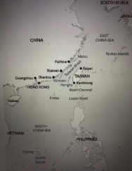
Nowadays the “dangerous ground” of the Spratlys is extended to the northern part of South China Sea and the southern extremity of the East China Sea- the Taiwan Strait, a 97-nautical mile passageway separating China and Taiwan. China had always taken the position that Taiwan is one of China’s provinces invoking historical records. On the other hand, Taiwan has asserted its sovereignty since 1949 when the communists failed to take over the island. Taiwan gradually transitioned into a democratic nation and a prosperous one. The US while having no formal diplomatic relations has committed to assist in defending Taiwan and in fact did so in the mid-1950s. Twelve countries have since established diplomatic missions. By the way, before the Philippines adopted the “One China Policy” in 1975 Taiwan sent a cadet to the Philippine Military Academy but was later recalled.
Many foreign security analysts consider China’s continuing show of force in the Taiwan Strait is meant to coerce Taiwan into adopting a flexible posture of neither declaring independence nor cementing defense alliance with a foreign power. China has been preparing and conditioning its population for a possibility of armed confrontation with Taiwan and its partners and allies. It frequently conducts military exercises involving land, air, naval, cyber and space forces. In addition, China’s maritime militia continues to deplete the fishery stocks in the maritime areas surrounding Taiwan.
With the recent China’s statement that Taiwan Strait is part of its EEZ and requires all vessels to inform it of their presence and intentions each time they navigate the waterway, the US Navy continued to conduct freedom of navigation sorties clearly sending the message that such actions are allowed under international law. Given the presence of competing forces in the strait the chance of violent engagements is not farfetched. This leads to three possible scenarios according to some research analysts.
The first is for China to invade Taiwan’s periphery by attacking Taiping Island (Itu Aba) in the Spratlys, Pratas (Dongsha) Islands in the southwest, Penghu Islands (Pescadores) including Kinmen and Matsu in the west. The principal objective is to exhaust Taiwan defense resources without necessarily forcing its allies and partners to actively engage in the defense of those islands. The second scenario is to quarantine Taiwan. This will affect the entry and departure of commercial and military flights to and from Taoyuan (Taipei) airport and merchant vessels in Kaohsiung seaport. Tourism and trade will be adversely affected. Allies may initiate counter-quarantine in the Malacca, Lombok and Makassar straits to prevent China-bound/outbound merchant vessels from delivering critical commodities like oil and exporting products for trading partners. This scenario is escalatory and many nations in the region would be affected.
The third scenario is for China to invade Taiwan mainland. This will be a combination of siege, amphibious landings and air assault. In terms of manpower, equipment and sustainability China obviously has an edge. However, in terms of readiness and the will to fight Taiwan may have the advantage. The Ukraine war is an example of the will to fight an invader, the readiness of the defending forces to simultaneously engage the enemy in many battlefronts and the collective action of the leading economies in the free world to safeguard sovereignty, independence, territorial rights, free and open market, and equal trading opportunity.
Due to our proximity to Taiwan and our alliance to one of the key players in the “dangerous ground” our defense planners must craft contingency plans and formulate and validate strategies that will protect our national security interests. In the words of India’s Prime Minister Narendra Modi, “Rules and norms should be based on the consent of all, not the power of the few.” Let us hope that “rules and norms” govern the behavior of all the stakeholders in the “dangerous ground” to avoid disorder and conflict and instead embrace peace, progress and harmony.