PART I
“DUTERTE: ‘MINING FIRMS FUNDING DESTABILIZATION PLOT.’
President Rodrigo Duterte on Monday accused some mining firms of financing what he called a ‘destabilization’ plot against his Administration.”
Manila Times, 14-March-2017
During a presscon in Malacañang with Senate President Aquilino Pimentel III, and House Speaker Pantaleon Alvarez on 13-March-2017, President Rody Duterte said mining firms were funding the political opposition to undermine his Government.
P. Duterte made the statement even as he defended anew Environment Secretary Regina Paz “Gina” Lopez for ordering the closure of mining firms alleged to have violated mining regulations. Only last 11 March and on other occasions afterwards, the President said he was willing to lose P70 billion in mining tax revenues, as he reiterated his support for Lopez. Showing photos of the ill effects of destructive mining, P. Du30 slammed mining companies that had failed to follow regulations.
Having watched the hearings of the Commission on Appointments almost all week on television, and knowing personally DENR Secretary Gina Lopez, DOF Secretary Sonny Dominguez plus some of the mining people quite well, it occurred to this writer that there is a happy solution to be found in between the contending positions – if only there is sincere dialogue among the concerned stakeholders away from the glare of unhealthy publicity. Also, it is important for the President to stop talking as if our Government is about to collapse because of destabilizing attempts by powerful opponents.
No way. All P. Digong has to do is to get a daily 10-minute briefing jointly from his National Security Adviser Jun Esperon and Presidential Security Group Commander General Rolando Bautista (or their deputies), and he’ll find out that there is no such destabilization plot because it takes much, much more than the DENR and its “audits” to cause an incumbent Government’s downfall. Secretary Gina Lopez and Secretary Sonny Dominguez are both correct in their arguments, because they are just trying to do a good job – according to their respective mandates.
P. Du30 appears to begin to panic by talking about conspiracies by people whom he can easily discipline. By constantly repeating the now-dirty word “destabilization,” P. Digong is driving away potential investors, tourists and other foreign assets, while unduly alarming our own people. This is probably one reason why our peso is down P50.30 to $1.00, while the cost of basic commodities keeps rising.
On the other hand, this writer believes that the huge anticipated revenue loss with the closure of most mining activities countrywide of some P70 billion will not kill the country. Somewhere is a win-win solution – and P. DU30, Gina Lopez and Sonny Dominguez need not lose their jobs, and so could Filipinos preserve the environment – similar to our successful Benham Rise claim where the DENR, through its National Mapping and Research Information Authority (NAMRIA), also played a leading role in this major inter-agency/inter-disciplinary endeavor.
THE IMPACT OF EXECUTIVE ORDER 45, S-1993. It will be recalled that on 05-January-1993, through the issuance of EO 45 by then President FVR, the government approved a synchronized, common reference system for the accurate surveying and mapping of natural resources, administrative and cadastral boundaries called the Philippine Reference System of 1992 (PRS92).
In the different local government offices around the country, DENR officials painstakingly explained to local chief executives and their constituents in at least 42,000 barangays the impact of this new program that transformed and integrated all the cadastral surveys and maps of the DENR Land Management Sectors to resolve and minimize overlaps and other inaccuracies under the old system of land mapping known as the Triangulation Network of the Philippines.
PRS92 ensures a unified, consistent and reliable geographic information database used in many planning and policy/decision-making activities of both Government and private organizations. These activities include, among others, land reform and administration, infrastructure and energy development, social and environmental initiatives, marine and ocean affairs, disaster and risk mitigation, and scientific and engineering studies. PRS92 also seeks to improve the economic status of the country, alleviate poverty, promote sustainable development, and support public order and safety. (NAMRIA’s PRS92 Newsletter, 1st Quarter 2009, Vol. II No. 1).
The recent emergence of the issues around Benham Rise has heightened the importance of that 24-year old adoption of PRS92, which in its earlier stages was assisted by the Australian Government. Its provisions are as follows:
EXECUTIVE ORDER NO. 45
ADOPTING THE PHILIPPINE REFERENCE SYSTEM OF 1992 (PRS92) AS THE COUNTRY’S STANDARD REFERENCE SYSTEM FOR SURVEYSWHEREAS, the NAMRIA is mandated to establish a nationwide geodetic control network of control points that serves as a common reference system of all surveys in the country;
WHEREAS, the Natural Resources Management and Development Project of the DENR in cooperation with the Coast and Geodetic Survey Department of NAMRIA has completed the establishment of the first order geodetic control network in the Philippines through the use of the global positioning system (GPS);
WHEREAS, the new network is now capable of supporting the integrated surveying and mapping programs of the Government for sustainable management and development of the environment and natural resources, and for infrastructure activities;
NOW, THEREFORE, I, FIDEL V. RAMOS, President of the Republic of the Philippines, do hereby order:
SECTION 1. The new geodetic control network known as Philippine Reference System of 1992 (PRS92) is adopted as standard reference for all surveying and mapping activities of the country.
SECTION 2. All new surveys and maps shall henceforth be referred to the new network. All old surveys shall be integrated into the new network including the adjustment of the coordinates of their corresponding maps. There shall be a transition period up to year 2000 to allow integration of the old surveys, after which only PRS92 shall be recognized as the standard reference system for all surveys and maps in the country.
SECTION 3. The DENR shall promulgate the guidelines to implement the provisions of this Order.
SECTION 4. This Order shall take effect immediately.
Approved in the City of Manila, Philippines, this 5th day of January, in the year of our Lord, nineteen hundred and ninety-three (1993).
Signed by FVR and Chief Presidential Legal Counsel Justice Antonio Carpio.
BENHAM RISE: HOW THE SHELF WAS WON. While surfing the internet in search of background material on Benham Rise, this writer ran into a previous article of the DENR with regards to the implementation of the United Nations Convention on the Law of the Sea (UNCLOS).
This little-known article describes the first major expansion of the Philippines’ maritime boundaries since the late 1970s when it declared its exclusive economic zone (EEZ). This happy outcome is a tribute to the quiet and diligent work and collaboration by a team of public servants, scientists and legal experts who pursued the claim for over a decade.
In their article with above title, authors Dr. Jay Batongbacal (Professor, U.P. College of Law and Legal Advisor, Technical Working Group, Philippine Extended Continental Shelf Project) and Efren Carandang (Deputy Administrator, NAMRIA and Project Manager, Philippine Extended Continental Shelf Project) narrated:
“The story of the Philippine claim to Benham Rise began with a workshop in 2001 to assist the DFA and the DENR’s NAMRIA with regard to the implementation of the Law of the Sea. Ms. Suzette Suarez of the U.P. Institute of International Legal Studies (UP-IILS) organized the workshop to discuss the requirements for claiming extended continental shelf (ECS) areas for the Philippines. Dr. Teodoro Santos of the U.P. National Institute for Geological Sciences (UP-NIGS) identified and proposed Benham Rise, then a relatively unknown area of the Pacific Ocean east of Luzon, as a possible ECS area in addition to areas west of Palawan. This resulted in an inter-agency Memorandum of Agreement among key government agencies and the academe to work together to make the ECS claims.
“Under then administrator (Retired Police General) DIONY VENTURA, the NAMRIA set itself to the task of conducting the extensive hydrographic surveys required as a basis for the claim. They commissioned the desktop feasibility study by the Norwegian firm BLOMASA with Norwegian assistance. Afterwards, the NAMRIA’s Coast and Geodetic Surveys Department sent its two survey ships, the PRESBITERO and VENTURA, on several cruises to the Pacific to map the seabed beyond 200 nautical miles away and more than 5,000 meters deep.”
Note: From NAMRIA’s brochure on BRP Hydrographer PRESBITERO and BRP Hydrographer VENTURA, it was stated, among others, that these vessels were purchased through state-to-state soft-loan facility from the Spanish Government, which President FVR visited in September 1994. They were built by Factoria’s Vulcano Shipyard in Vigo, Spain from 14-May-1997 to 04-August-1998. The PRESBITERO arrived in Manila on 16-October-1998, after brief stops in Jeddah, Saudi Arabia and Singapore and test surveys in Sulu Sea and Surigao Strait. The VENTURA arrived in Manila on 07-January-1999. PRS92 and the two vessels, PRESBITERO and VENTURA, surely served as solid foundations for our Benham Rise ECS victory.
Part II
BENHAM RISE: NURTURING OUR GOD-GIVEN BLESSINGS
“LORENZANA ON CHINESE SHIPS: WHAT INNOCENT PASSAGE?
Defense Secretary Delfin Lorenzana is disputing China’s claim that its survey ships, spotted last year at Benham Rise – a vast undersea region east of Luzon – were there merely on ‘innocent passage.’ As far as we are concerned they have no business going there,” he said. (Malaya, 14 March 2017)
The Du30 Government is “worried” about the Chinese activity at Benham Rise. “We will do something there, maybe we will increase our patrols at the same time, maybe we will also put something there, structures that say this is ours (Philippines)… They (Chinese) know that Benham Rise was awarded to us by the United Nations,” Defense Secretary Lorenzana also said.
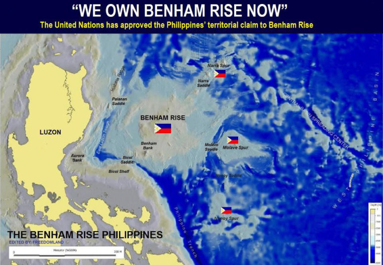
In 2012, the United Nations declared Benham Rise, a 13-million hectare undersea region east of Luzon rich in biodiversity and fish stocks, part of the Philippine continental shelf.
In early March this year, Lorenzana said the AFP and support maritime services monitored Chinese survey ships at the Benham Rise from July to December 2016, conducting surveys apparently for the deployment of submarines. However, the Chinese Foreign Ministry (MOFA) said China’s research ships were “purely carrying out normal freedom of navigation and right of innocent passage, and there were no other activities or operations.”
DND plus Philippine Coast Guard (DOTr) sources and FVR say: “If that’s innocent passage, you know what innocent passage is, it’s like going from point “A” to point “B” straight and your steaming speed is constant. What the AFP saw … where Chinese ships steaming at low speed and they stopped in one area, stayed there for a few days and transferred to another place. That is not innocent passage.”
SIGNIFICANCE OF PRS92. The Philippine reference system of 1992 (PRS92) is a homogeneous national National Network of Geodetic Control Points (GCPs), marked by survey monuments (or Mojons), that has been established using GPS technology. GPS is an all-weather, high precision, global satellite positioning system that revolutionized navigation and surveying operations – on land, under water, and now out there in cyberspace.
By virtue of EO 45 issued by the FVR Administration on 05 January 1993, PRS92 became the standard reference system for all surveying and mapping activities in the Philippines. The order also mandated that all new surveys and maps shall be referred to the new network and all old surveys be integrated into it.
PRS92 is the fundamental component of the National Spatial Data Infrastructure (NSDI) which serves as the country’s standard coordinate reference system for all survey and mapping activities. It provides the means through which base and thematic datasets can be consistently inter-related geographically.
The primary stakeholders of PRS92 are all government agencies engaged in surveying and mapping like the Departments of Environment and National Resources (DENR); Agriculture (DA); National Defense (DND); Public Works and Highways (DPWH); Transportation (DOTr); Information and Communications Technology (DICT); Agrarian Reform (DAR); and other agencies having interests in land, maritime and aerospace mapping.
Private surveyors, foresters, and academic institutions are also important users. Private and public landowners and fisherfolk are the major beneficiaries while the general public that is benefiting from the programs of the above-mentioned Government agencies is the ultimate beneficiary.
PRS92 was first implemented through EO 45 under the Ramos Administration (with deadline set at year 2000). It was amended through EO 280 to extend its implementation by 2005. EO 321 was issued by President Gloria Macapagal-Arroyo in order to complete the adoption and integration of old surveys into the system until year 2010.
MORE HISTORICAL BACKGROUND. Let us continue our 19 March issue (Part 1) with Dr. Jay Batongbacal’s and NAMRIA Deputy Administrator Efren Carandang’s article “Benham Rise: How the Shelf was Won,” Thus: “In 2007, the Cabinet-level Commission on Maritime and Ocean Affairs (CMOA) created a Technical Working Group to prepare the Philippines’ formal claims or ‘Submissions,’ to be filed with the United Nations’ Commission on the Limits of the Continental Shelf (UN-CLCS). NAMRIA inaugurated the Philippine ECS Project under then Director Efren Carandang. Its first task was to recruit scientific expertise, to which Dr. Santos and the UP-NIGS quickly responded. Ms. Nancy Aguda and Jenny Anne Barretto, both young geologists of UP-NIGS, together with NAMRIA Engineer Dennis Bringas, undertook much of the very tedious technical analysis, supported by a team of cartographers, hydrographers, and I.T.-specialists detailed from other NAMRIA offices NAMRIA. Many experts from the UP-NIGS such as Dr. Mario Aurelio and Dr. Mahar Lagmay were also called in.”
(It will be recalled that former Administrator and retired Police Director Diony Ventura, was the pioneer NAMRIA component in this Project. Ventura had also served as FVR’s Aide-de-Camp back in the 1970s/80s.)
Additional data was gathered from both local and international institutions, and NAMRIA procured the latest in computer hardware and software to process them. Participants from the DOJ, DOE, PCG, NSC, and other relevant agencies also joined discussions on policy issues about the claim. The team then produced draft submissions with advice from the UK National Oceanography Centre (NOC) based in Southampton.
At that time, there was very little first-hand information about the actual intricacies of writing and supporting ECS submissions with the UN-CLCS. NAMRIA contacted U.P. Law Professor Jay Batongbacal, who was then still taking up his doctorate in Canada, to join the project, participating in the project’s second major workshop via Skype. Professor Jay Batongbacal then met with Commissioner Galo Carrera of Mexico, a UN-CLCS member and colleague who had given maritime boundary workshops in the Philippines back in the 1990s.
For help on the technical aspects, NAMRIA engaged the GNS, New Zealand’s equivalent of the UP-NIGS and PhiVolcs. New Zealand had just announced its success in securing approval of the New Zealand ECS claim. The Institute of Geological and Nuclear Sciences of New Zealand’s (GNS) team provided the Philippine team with information and advice on their actual experiences in making their claim, as well as enhanced their knowledge and capabilities in analyzing and interpreting the data.
The Philippine team then decided to make the “Submission for Benham Rise” first. With the new project participants, a completely different version of the “Submission” emerged from the previous drafts. Commissioner Carrera of Mexico facilitated an exchange of views between the Philippine ECS Project team and their counterparts in Mexico, who had also successfully completed their own ECS submission. He also visited the Philippines to work directly with our Project team in marathon technical workshops. All previous work was reviewed, re-analyzed, and portions rejected in order to produce the new “Submission.” Rolando Peña of UP-NIGS served as technical editor. Thousands of pages of raw data and documents had to be collated, digitally reproduced, and professionally packaged by the NAMRIA‘s I.T. Group led by Deputy Administrator Linda Papa, and integrated into customized browser software, and which were later delivered to our Permanent Representative to the U.N. in New York.
Meanwhile, there were many activities in the Philippine Congress on the proposed amendment of the Philippine archipelagic baselines law, which was an important prelude to the making of a “Submission” to the U.N. NAMRIA undertook PRS92 surveys of the proposed basepoints, and prepared several baseline configurations for Congress, which passed the new baselines law in March 2009.
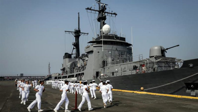
Philippines to patrol Benham Rise. Photo Credit: Aljazeera News
The Philippines submitted its “submission” to the U.N. on 08-April-2009 – a month before the original deadline. On 15-August-2009, the ECS team made its first formal presentation to the U.N. Commission en banc, with then Ambassador Hilario Davide introducing the Philippine Delegation led by Ambassador Minerva Falcon.
BENHAM RISE DEVELOPMENT AUTHORITY. Last month, Senator Sonny Angara filed Senate Bill no. 312, “The Benham Rise Development Authority Act,” in the light of consistent reports of aggressive Chinese activity in the area as previously narrated. Obviously, the Senate finds it imperative to tackle national security concerns soonest in the wake of reports of suspicious Chinese activities in the area since 2016.
There should be no problem for the Philippines over Benham Rise because (1) the Philippines is the sole claimant; and (2) the U.N. Commission on the Limits of the Continental Shelf (UN-CLCS) ruled in 2012 that Benham Rise is part of the Philippines’ Extended Continental Shelf (ECS). It is not Philippine territory – we have no ”sovereignty” over it, but we have “sovereign rights” – exclusive rights to explore and exploit the oil, gas, and other natural resources in that undersea plateau which is as big as Luzon (if not bigger). It is only to the east of Luzon (Pacific Ocean side) where we have no rival claimant. We should be thankful we have Benham Rise to ourselves, to develop as a new source of natural resources for Philippine industry and progress.
RECOMMENDATIONS. Congress would do well to enact asap Senator Sonny Angara’s bill for a “Benham Rise Development Authority (BRDA),” and for the DU30 Administration to start drawing up plans for this potentially rich area for its control, security, development, national advantage, and global use.
A combined task force of AFP-PNP-PCG units and also intelligence/surveillance assets of other relevant departments, plus private maritime and oceanographic agencies should back up the BRDA. This requires constant consultation and inclusive consensus.
Kaya ba natin ito?
_____________________
Please send any comments to fvr@rpdev.org. Copies of articles are available at www.rpdev.org.