Brief History
Palawan’s textured history can be traced back over millions of years. Bone fragments, the skull cap remains and tools of the Tabon Man – one of the oldest remnants of human inhabitants found in the Philippines at 22,000 years old – were discovered in 1962 in the Tabon Caves in Quezon, Palawan. It is believed that these cave dwellers came from Borneo. Further exploration of the caves revealed burial jars, jade ornaments, animal bones and human fossils indicating habitation as far back as 47,000 years ago. Geological studies have also revealed limestone formations on the islands date back 25 million years.
But what’s in a name? The origin of the name ‘Palawan’ too has a contested genealogy. Some argue it arises from the Chinese “pa lao yu” meaning Land of the Beautiful Harbours. Others maintain that it was derived from a plant locally known as palwa. But the popular belief – with perhaps the greatest credence – is that Palawan owes a debt to the Spanish word “paragua” as the central island’s shape resembles that of a closed umbrella.
Long before it became “The Best Island in the World” and a major tourist destination, Palawan had a significant role over the years especially during those dark days of colonization from one colonizer to another. The early history of this province was determined by a team of researchers led by Dr. Robert Fox who has found the evidence of life from the remains they unearthed in the Tabon Cave – proving that man has continuously lived in Palawan for more than 50,000 years ago. The remains of the “Tabon Man” was found in the municipality of Quezon. Although the origin of the cave dwellers was not yet established, anthropologists believe that they came from Borneo. Until now, excavations and explorations are still done in the Tabon Cave which was dubbed as “The Cradle of Philippine Civilization” to search for other yet undiscovered items and remains that could be useful for further studies.
Spanish Era
After the death of Magellan, the remaining members of his fleet sailed to Palawan where the bounty of the land saved them from starvation, thus, named it “Land of the Promise” by Magellan’s chronicler, Antonio Pigafetta. The northern Calamian Islands were first to come under Spanish authority and were later declared a separate province from mainland Palawan. In the early 17th Century, Spanish friars sent out missionaries in Cuyo, Agutaya, Taytay, and Cagayancillo but they ended up meeting resistance from the Moro community who were occupying the place. Later, before the 18th century, Spain began building churches that are enclosed by garrisons for protection against Moro raids in the towns of Cuyo, Taytay, Linapacan, and Balabac. In 1749, the Sultanate of Brunei surrendered southern Palawan to Spain.
In 1818, the entire island of Palawan which was then called Paragua was organized as a single province and named it Calamianes with Taytay being its capital. However, in 1858, the province was divided into two provinces namely Castilla, covering all the municipalities in the northern part with Taytay as its capital, and Asturias in the southern mainland with Puerto Princesa as its capital. Later on during the Spanish colonization in the Philippines, Cuyo became the second capital of Palawan from 1873 to 1903.
American Regime
After the Philippine-American war in 1902, the Americans established a civil rule on the northern part of Palawan, calling it the province of Paragua. In 1903, pursuant to the Philippine Commission Act No. 1363, the province was reorganized to include its southern portions and renamed it into Palawan, and Puerto Princesa was declared its capital. During this era, bringing the people closer to the government was among the priority plans of the Americans along with the building of schools, and the promotion of agriculture.
Geography
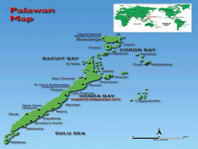
The geography of Palawan is composed of the long and narrow Palawan Island, plus a number of other smaller islands surrounding the main island. The Calamianes Group of Islands to the Northeast consists of Busuanga Island, Coron Island and Culion Island. Durangan Island almost touches the westernmost part of Palawan Island, while Balabac Island is located off the southern tip, separated from Borneo by the Balabac Strait. In addition, Palawan covers the Cuyo Islands in the Sulu Sea. The disputed Spratly Islands, located a few hundred kilometers to the west, are considered part of Palawan by the Philippines, and is locally called the Kalayaan Group of Islands.
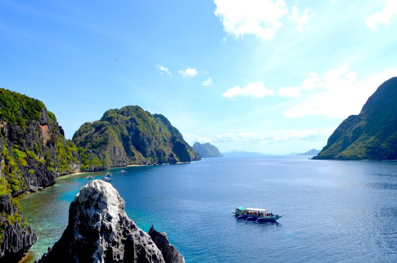
Palawan’s almost 2,000 kilometers (1,200 mi) of irregular coastline are dotted with roughly 1,780 islands and islets, rocky coves, and sugar-white sandy beaches. It also harbors a vast stretch of virgin forests that carpet its chain of mountain ranges. The mountain heights average 3,500 feet (1,100 m) in altitude, with the highest peak rising to 6,843 feet (2,086 meters) at Mount Mantalingahan. The vast mountain areas are the source of valuable timber. The terrain is a mix of coastal plain, craggy foothills, valley deltas, and heavy forest interspersed with riverine arteries that serve as irrigation.
The province is the largest of all the provinces in the Philippines in terms of total area of jurisdiction straddling the western region of the country. It is located in the MIMAROPA Region or Region IV-B of Southern Tagalog provinces. It lies between the West Philippine Sea and the Sulu Sea stretching from Mindoro in the northeast to southwest direction towards Borneo covering almost the length of Sulu Sea and occupying the rich vastness of the West Philippine Sea south of Manila. The province is named after its largest island, Palawan Island (09° 30’N 118° 30”E) measuring 450 kilometers (280 miles long) and 50 kilometers (31 miles) wide. It is rich in marine resources both for food and tourism purposes that it aptly comprises the largest eco-tourism industry of the Philippines. Its terrestrial resources also boast of virgin forests with the finest and hardest wood in the country complemented by rich mineral resources. The province is also known as the last frontier of the country with known oil reserves in its seabed. The Malampaya Natural Gas Power Project, which lies just 50 kilometers offshore from El Nido in northwest Palawan, provides 2,700 megawatts of electricity for the island of Luzon, which is the center of industries and population of the Philippines. The Galoc Oil Field just northeast of Malampaya produces “sweet oil” which only tells that the seabed of Palawan is indeed rich in fossilized fuel since it is part of the continental shelf running from the oil rich Borneo.
Other oil explorations conducted find that Palawan contains large deposits of oil in its continental shelf from north to south which when fully developed will provide the country with much needed energy to boost the country’s programs of development to truly become a tiger economy in Asia. Its deep harbors in Buliluyan in the southern part of the province is being developed by the provincial government in connection with the BIMP-EAGA (Brunei-Indonesia-Malaysia-Philippines East ASEAN Growth Area) as an open port to cater to the envisioned economic activities in this part of the region. The pier and the wharves would also serve as fish ports with the rich fishing ground in the West Philippine Sea. As a natural maritime area of the country, the island could become a major source of maritime industries like shipbuilding, given the right direction and infrastructure necessary for such heavy industries since Palawan is also one of the largest sources of nickel in the world, being mined and produced by Rio Tuba Nickel Mining Corporation and Coral Bay Nickel in the southern part of the province.
Excerpted from the author’s dissertation on dividing the big province into smaller provinces in 2014 and made into law in 2019, to be ratified by the people in an incoming plebiscite.
About the author:
COMMODORE ARMANDO S RODRIGUEZ AFP (RET), PH.D MNSA is a native of Sta. Cruz, Laguna, a member of PMA Class ‘76 and presently residing in Puerto Princesa City, Palawan. He is currently teaching at Palawan State University in the undergraduate school; and at Holy Trinity University in both the undergraduate and graduate school. He authored the division of Palawan in his dissertation in 2014 and was favorably endorsed by the province to Congress and made into law by President Rodrigo Duterte, which paved the way for the possibility of realizing his dream of seeing a more progressive and dynamic Palawan Island Region.
He authored also in the past the “Joint Fishing Venture” between Indonesia and the Philippines while assigned in Marore Island as Border Crossing Officer, the “Task Force Sagip-Buhay Dagat” in Davao City in 1994 with 12 government agencies signing the MOA with the support of then Mayor Rodrigo Duterte to protect and conserve Davao Gulf initially but which was made into law by President Fidel Ramos in 1996 which became a model for inter-agency concept in coordinative efforts of government agencies.
He was awarded the Outstanding Achievement Medal by President Fidel Ramos during the AFP Day in 1996 at Camp Aguinaldo. COMMODORE RODRIGUEZ has mentored thousands of young and ambitious students of PSU and HTU with some of them having already graduated from PMA and the PNP Academy, not to mention faculty and members of the civil government who have likewise earned their graduate degrees.
He is a holder of a Doctor of Philosophy in Public Administration, a Master in National Security Administration, and Law at PSU. He is married to Maria Theresa Vicente Rodriguez of Puerto Princesa City where she is currently the Chief of Business Permit and Licensing Office of the City government.