Last May, Secretary of Defense James Mattis retitled Pacific Command (PACOM), the largest of the six U.S. unified combatant command to United States Indo-Pacific Command (USINDOPACOM). The area of responsibility remains unchanged for the former PACOM. The decision to retitle is in alignment with the increasing connectivity between the Indian and Pacific Oceans. Moreover, the retitling is fitting in the present geostrategic environment. China’s reach has expanded all the way to Africa with its first overseas base. With China’s naval vessels transiting the Indian Ocean routinely and a growing list of maritime infrastructure projects, its interests are no longer limited to the Pacific. They now span the Indian Ocean.
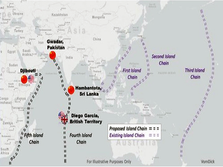
China’s redefinition of the regional security environment, and shifting it toward the Indian Ocean would result to three Pacific “island chains.” This should grow to include the Indian Ocean as well. The island chain is a geographical security concept used to illustrate a defensive or offensive perimeter by linking islands and other larger landmasses together. Since American military planners in the 1940s identified the initial chain as a means to secure the Soviet Union’s and the People’s Republic of China’s maritime approaches, the number of existing chains has now grown to three. John Foster Dulles is attributed with designating the islands stretching from the Kurils (Japanese islands) and the Ryukyus to Taiwan, Philippines, and Indonesia as the “first island chain” in the 1950s. (VornDick, W. n.d.) The “second island chain” runs from Japan to Indonesia, while the “third island chain” extends from Severo-Kuril’sk islands of Sakhalin, Russia to New Zealand in the South Pacific.
Prospective fourth and fifth island chains in the Indian Ocean could be delineated in a multitude of ways, and the following methods are only illustrative, based on their alignment with existing U.S. military bases and Chinese interests. The “fourth island chain” commences in Gwadar, hugs the western coasts of India and Sri Lanka, and then passes southward from Hambantota, through the Indian Ocean, and passing the U.S. military base, Diego Garcia. The fourth chain signifies the People’s Liberation Army (PLA) Navy’s ability to not only challenge the American security interests at Diego Garcia, but also China’s strategic competitor – India. (VornDick, W. n.d.)
Jutting out from the Gulf of Tadjoura in Djibouti, the “fifth island chain” passes through the Gulf of Aden, proceeds east as it outlines the Horn of Africa, and then south along the east coast of Africa. This reflects the importance of China’s developing commitments and influence in Africa and the western Indian Ocean, signified by its base at Doraleh. (VornDick, W. n.d.)
Given the background above, USINDOPACOM will serve as deterrence and maintain stability in the region with the changing geostrategic status quo, now that China has gathered the experience, learned the requisite lessons, and gained enough know-how in its objective for a total hegemony. It is only a matter of time before more Chinese bases are built. Just as U.S. Planners retitled Indo-Pacific Command to reflect the current geostrategic realities, USINDOPACOM will strive along with allies and partners to enhance stability in the Indo-Asia-Pacific region by promoting security cooperation, encouraging peaceful development, responding to contingencies, deterring aggression and, when necessary, fighting to win. This approach is based on partnership, presence and military readiness. It recognizes the global significance of the Indo-Asia-Pacific region and understands that challenges are best met together.
USINDOPACOM’s Area of Responsibility (AOR) encompasses the Pacific Ocean from Antarctica at 92°W, north to 8°N, west to 112°W, northwest to 50°N/142°W, west to 170°E, north to 53°N, northeast to 62°30’N/175°W, north to 64°45’N/175°W, south along the Russian territorial waters to the People’s Republic of China, Mongolia, the Democratic People’s Republic of Korea, the Republic of Korea, and Japan; the countries of Southeast Asia and the southern Asian landmass to the western border of India; the Indian Ocean east and south of the line from the India/Pakistan coastal border west to 68°E, south along 68°E to Antarctica; Australia; New Zealand; Antarctica, and Hawaii. (“United States Indo-Pacific Command” n.d.)
About the author Samuel J Marcelo works presently as Operations Research Analyst (GS-12) at Norfolk Naval Shipyard. He is presently pursuing Joint Professional Military Education 1 through the Naval War College, Fleet Seminar Program at the Joint Forces Staff College, Norfolk, VA. He retired as Chief Petty Officer, US Navy, in September 2006.