About half of the world’s seaborne trade passes through the South China Sea (SCS) valued at US$5.3 trillion annually. The SCS dispute has the potential to overturn the United Nations Convention on the Law of the Sea (UNCLOS), the constitution for the earth’s oceans and seas. For the Philippines, at stake in the West Philippine Sea (WPS) are: (1) 80% of its exclusive economic zone (EEZ), comprising 381,000 km² of maritime space, and (2) 100% of its extended continental shelf (ECS), estimated at 150,000 km² of maritime space, aggregating to a huge maritime area larger than the Philippines’ total land area of 300,000 km². Either the Philippines keeps this huge maritime space, or loses it all to China.

Lecture delivered by Associate Justice Antonio
T. Carpio before the Philippine Military Academy
Alumni Association, AFP Theater, Camp General
Emilio Aguinaldo, Quezon City, 23 January 2016.
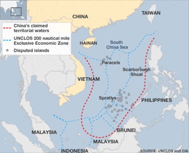
The root cause of the SCS dispute is China’s 9-dashed lines claim. China’s 9-dashed lines claim encloses 86% of the entire SCS. This is equivalent to 3 million km² out of SCS’ 3.5 million km² surface area. The 9-dashed lines map was submitted by China to the United Nations on 7 May 2009. China did not explain the legal basis for the dashes, which had no fixed coordinates. The Philippines, Vietnam, Malaysia and Indonesia have protested.
“China has indisputable sovereignty over the islands in the SCS and the adjacent waters, and enjoys sovereign rights and jurisdiction over the relevant waters as well as the seabed and subsoil thereof ” as per China’s Note Verbale. The terms “adjacent” and “relevant” waters are not UNCLOS terms. China refuses to explain the meaning of “adjacent” or “relevant” waters. Do these terms mean that China claims all the waters and resources enclosed by the 9-dashed lines? We shall examine China’s acts, regulations, declarations, and practices in the SCS to understand how China interprets and applies the terms “adjacent” and “relevant” waters.
In 1988, China seized Subi Reef from the Philippines by erecting a radar structure and military facilities on the reef. Subi Reef is a Low-Tide Elevation (LTE) outside of the Philippines’ EEZ but within its ECS. Subi Reef is just outside the 12 NM territorial sea of the 36-hectare Pagasa (Thitu) Island, the largest Philippine occupied island in the Spratlys. Subi Reef is 231 NM from Palawan and 502 NM from Hainan. Under UNCLOS, only the Philippines can erect structures or create an artificial island on Subi Reef. Under UNCLOS, Subi Reef, an LTE, cannot be used as a military facility as Subi Reef waters are part of the high seas of SCS. Article 88 of UNCLOS mandates: “the high seas shall be reserved for peaceful purposes.” Subi Reef ‘s total area is 16 km² with a depth of 22 meters. Subi Reef ’s location, size and depth make it ideal for a naval base with an airfield. As of 23 December 2015, China has created an artificial island of 500 hectares in Subi Reef.
In 1995, China seized Mischief Reef (Panganiban) from the Philippines. Mischief Reef, which is 125 NM from Palawan, is an LTE within the Philippines’ EEZ. As an LTE beyond the territorial sea of any state, it is part of the submerged continental shelf of the adjacent coastal state, which is the Philippines. Mischief Reef is a circular atoll with a diameter of 7.4kms, and its lagoon has an area of 3,600 hectares with an average depth of 26 meters. Under UNCLOS, only the Philippines can exploit its natural resources or erect structures. As of November 2015, China has created an artificial island of 590 hectares out of a planned 800 hectares. China can garrison thousands of troops on Mischief Reef which is 596 NM from Hainan. As of 8 January 2016, Mischief Reef ‘s northwest side has a 1900ft seawall, constructed infrastructure, including housing, artificial turf, cement plants, and docking facilities. With an air and naval base in Mischief Reef between Palawan and Philippine-occupied islands in the Spratlys, China can block Philippine ships from re-supplying its islands in the Spratlys.
In February 2010, the Philippines awarded a Service Contract to Sterling Energy for Block SC 72 in Reed Bank. China protested, sending two Note Verbales to the Philippines, expressing “its strong objection and indignation,” asserting “indisputable sovereignty, sovereign rights and jurisdiction over the Nansha Islands (Spratlys) and its adjacent waters.” China demanded the Philippines “withdraw the Service Contract immediately, and withdraw the decision to award the Service Contract to Sterling Energy, although Block SC 72 is 85 NM from Palawan, thus, well within the Philippines’ EEZ.
In August 2010, the Chinese First Secretary showed the Nido vice president China’s 9-dashed lines map, and informed him that the area covered by Nido Petroleum’s service contract (Block SC 58) was “claimed by” the China. Since then, Nido Petroleum has not made any exploration within Block SC 58.
In 2011, the Philippines invited bids for the exploration of Areas 3 and 4 in Reed Bank, well within the Philippines’ EEZ. On 4 July 2011, China protested and sent a Note Verbale to the Philippines stating: “The Chinese government urges the Philippine side to immediately withdraw the bidding offer in Areas 3 and 4, refrain from any action that infringes on China’s sovereignty and sovereign rights.” In March 2011, two Chinese coast guard vessels, the CMS-71 and CMS-75, prevented a Philippine-commissioned ship, the MV Veritas Voyager, from undertaking an oil and gas survey in Reed Bank which is entirely within the Philippines’ EEZ. The 9-dashed lines cut through Malampaya, the Philippines’ largest operating gas field supplying 40% of Luzon’s energy requirement. But in 2012, China does invite an international bidding for explorations within EEZ and ECS of Vietnam. China published this map, naming it “Location for part of open blocks in waters under jurisdiction of China available for foreign cooperation” in 2012.
In 2013, China released an official new map of China, adding a 10Thdash on the eastern side of Taiwan. In this map, China claims the 10-dashed lines are its “national boundaries,” again without explaining legal basis or giving fixed coordinates of the dashes.In the 7 June 2013 Note Verbale to China, the Philippines stated it “strongly objects to the indication that the 9-dashed lines are China’s national boundaries in the WPS/SCS.” China’s claim that the 9-dashed lines are China’s “national boundaries” contradicts its assurance to the world that there is “freedom of navigation and overflight in the SCS in accordance with international law.”
Since 2012, China has periodically been laying sovereignty steel markers on the seabed of James Shoal. China claims James Shoal as its southernmost border. James Shoal is fully submerged at 22 meters under water, situated more than 950 NM from Hainan and more than 400 NM from Itu Aba. Under UNCLOS, the maximum maritime zone a state can claim is 350 NM from baselines along its coast. Under international law, a state’s border must either be a land territory, river, or territorial sea — which are all subject to its full sovereignty. A state cannot appropriate as its sovereign territory a fully submerged area beyond its territorial sea. James Shoal is 80kms from Malaysia’s coast in Bintulu, Sarawak, well within Malaysia’s EEZ. A Chinese taskforce composed of 3 warships from the SCS Fleet of the Chinese Navy held a sovereignty oath swearing ceremony on 26 January 2014 around James (Zengmu)Shoal, off the coast of Sarawak, Borneo in the SCS. The Singapore Straits Times quoted China’s Foreign Ministry spokesman Qin Gang stating that Malaysia did not lodge any protest against China.
In 2012, China seized Scarborough Shoal (Bajo de Masinloc or Panatag Shoal) from the Philippines. In November 2012, following a 3-monThstandoff between Philippine and Chinese vessels around the shoal, China informed the Philippines that Chinese coast guard vessels would remain permanently on the shoal. Scarborough Shoal, including its lagoon, has an area of 58 miles² or 150 km² (15,000 hectares). Located 124 NM from Zambales makes it well within Philippines’ EEZ. Scarborough Shoal is rich in fisheries and is one of the traditional fishing grounds of Filipino fishermen. Scarborough Shoal is a high tide elevation, with the biggest rock protruding 1.2 meters above water at high tide. As an island, Scarborough Shoal is entitled to a 12 NM territorial sea around it which amounts to 155,165 hectares of maritime space, more than twice the 63,600-hectare land area of Metro-Manila. Yet China likewise claims Scarborough Shoal as its 200 NM EEZ.
Article 35 of Hainan’s 2014 Fishery Regulations, which took effect on 1 January 2014, mandates that foreign fishing vessels “entering the waters under the jurisdiction of this province (Hainan) to engage in fishery operations or fishery resource surveys shall secure approval from relevant departments of the State Council.” The Fishery Regulations apply to Macclesfield Bank, which is part of the high seas.
The enclosed waters under Hainan’s administration comprise 2M km² out of the 3.5M km² total surface area of the SCS. Since 1999, China through Hainan has imposed unilaterally a 3-monThannual fishing moratorium, from mid-May to end July, on waters in and around the Paracels, Macclesfield Bank, and Scarborough Shoal.
Violators of the ban face fines, confiscation of fishing equipment, and criminal charges. In the 6 July 2015 Note Verbale, China demanded the Philippines “respect China’s territorial sovereignty, sovereign rights and jurisdiction, and educate its own fishermen, so that they can strictly abide by the fishing moratorium.” China warned that “Chinese law-enforcing authorities will strengthen their maritime patrols and other law enforcing actions, investigate and punish the relevant fishing vessels and fishermen who violate the fishing moratorium.”
The high seas have always been part of the global commons. The high seas cannot be subject to sovereignty by any state, before or after UNCLOS. Article 87 UNCLOS declares: “The high seas are open to all states, whether coastal or land-locked.Freedom of the high seas comprises, inter alia, freedom of fishing.” Article 89 UNCLOS declares: “No state may validly purport to subject any part of the high seas to its sovereignty.”
Therefore, by appropriating the fishery resources in the high seas of the SCS, China is committing a grand theft of the global commons making all states, coastal and landlocked, interested parties in the SCS dispute. All these acts of China demonstrate beyond doubt that China is claiming sovereignty, sovereign rights and jurisdiction to ALL the waters, fisheries, oil, gas, mineral resources, seabed and subsoil enclosed by the 9-dashed lines.
The Philippines loses 80% EEZ facing the WPS, including Reed Bank and part of Malampaya gas field.
Malaysia loses 80% EEZ in Sabah and Sarawak facing the SCS, and most of its active gas and oil fields. Vietnam loses 50% EEZ. Brunei loses 90% EEZ. Indonesia loses 30% EEZ facing the SCS in Natuna Islands, whose surrounding waters comprise the largest gas field in Southeast Asia. The Philippines will be left with a sliver of water as its territorial sea and EEZ. The Philippines and China will have a very long common sea border – 1,300 kms – from Balabac Island in southern Palawan to Yamin Island in northern Batanes. The dashed lines are just 64 kms from Balabac Island, 70 km from the coast of Burgos, Ilocos Norte, and 44 kms from Yamin Island.
China is mass-producing destroyers, frigates, corvettes and other warships at a faster rate than any other country during peacetime. The U.S. Office of Naval Intelligence reported, “During 2014 alone, more than 60 naval ships and craft s were laid down, launched, or commissioned, with a similar number expected through the end of 2015.” China launched its 25ThType 056 Corvette last 19 March 2015 out of 40 Type 056 Corvette fleet planned. The PLA Navy believes it can control the SCS wiTh20 Corvettes. China will deploy this year a 10,000-ton coast guard vessel, the world’s largest blue water coast guard vessel. A second 10,000-ton sister ship is under construction. China has more coast guard vessels than Japan, Vietnam, Indonesia, Malaysia, and Philippines combined. China’s Coast Guard is the largest blue water coast guard fleet in the world.
Under its 2015 “China Military Strategy,” China will shift from “off shore waters defense” to the combined “off shore waters defense” and “open seas protection.” The strategy states: “The traditional mentality that land outweighs the sea must be abandoned, and great importance has to be attached to managing the seas and oceans and protecting maritime rights and interests.”
An island above water at high tide is entitled to 12 NM territorial sea. If human habitation or economic life is possible, it is entitled to an EEZ. If there is a natural prolongation of its extended continental shelf, it is entitled to ECS up to where the natural prolongation ends, but not exceeding 150 NM from the outer limits of its EEZ. The maximum maritime zone a coastal state can claim is 150 NM from the outer limits of its EEZ. Yet China is claiming maritime zones more than 150 NM from the outer limits of its EEZ.
An LTE is a naturally formed area of land (rock, reef, atoll or sandbar) surrounded by water, above water at low tide but submerged at high tide.
An LTE is part of the submerged continental shelf. An LTE is not land or territory, and has no territorial sea or territorial airspace (Art. 13, UNCLOS). An LTE beyond the territorial sea is not subject to appropriation by any State (Nicaragua vs. Colombia, ICJ, 2012).Neither is an LTE entitled to a territorial sea or any maritime zone. A rock above water at high tide is entitled to a 12 NM territorial sea. Yet China has built artificial islands on 7 reefs.
China built on Fiery Cross Reef, Cuarteron Reef, Gaven Reef, Johnson South Reef, McKennan Reef, Mischief Reef, and Subi Reef. However, China has also dredged 10 other reefs for filling materials for the 7 reefs on which China has built islands, according to Capt. J. Ashley Roach (Ret), JAGC, USN. China’s deputy permanent representative to the UN, Wang Min, explained: “The primary purpose of these activities is to improve the working and living conditions of personnel stationed there, to better fulfill our international obligations concerning maritime search and rescue, disaster prevention, and mitigation, and to enable China to provide better services to vessels from China, her neighbors, and other countries sailing in the SCS.”
Fiery Cross Reef is 1 meter above water at high tide. It is outside Philippines’ EEZ but within its continental shelf. In 1987, UNESCO agreed that China would build a weather station on Fiery Cross Reef as part of UNESCO’s global oceanic survey. That weather station later turned out to be a Chinese military air and naval base. One of the islands built and completed by China in June 2015 is an airbase with a seaport. It has a 3,000-meter runway on a 274-hectare area on Fiery Cross Reef, larger than the 213-hectare Woody Island which hosts China’s airbase in the Paracels with a 2,700 meter runaway that can handle China’s fighter aircraft s and the H-6K strategic bomber. This artificial island will be larger than the combined 20 largest islands in the Spratlys; more than twice the area of Diego Garcia Island, the U.S. airbase in the Indian Ocean.
Johnson South Reef is an LTE within the Philippines’ EEZ. China, Philippines and others except the US nautical charts designate it as an LTE. As of November 2015, China has created an artificial island of 10.9 hectares in Johnson SouthReef.
McKennan Reef is an LTE within the Philippines’ EEZ and within 12 NM of Sin Cowe Island. As of November 2015, China has created an artificial island of 7.2 hectares in McKennan Reef. Gaven Reef is an LTE within 12 NM of Namyit Island, and is outside the Philippines’ EEZ but within its continental shelf. As of November 2015, China has created an artificial island of 13.6 hectares in Gaven Reef. Cuarteron Reef is a tiny rock above water at high tide outside the Philippines’ EEZ but within its continental shelf. As of November 2015, China has added 24.6 hectares to Cuarteron Reef.
China’s island-building violates the 2002 Asean-China Declaration of Conduct, which states that the parties undertake to exercise self restraint, such as refraining from inhabiting presently uninhabited islands, reefs, and shoals. Yet, in June 2015, China conducted its first air-sea military drill in the Bashi Channel between Taiwan and the Philippines. China announced that in the future it would conduct regular air-sea military drills in the Bashi Channel.
China has had a creeping expansion in the SCS from 1946 to 2015. Before World War II, China’s southernmost defense perimeter was Hainan Island. Before the war, China did not have a single soldier or sailor stationed in any SCS island outside of Hainan Island. Right after the war, China took over the Amphitrite Group of the Paracels and Itu Aba in the Spratlys following the defeat of the Japanese. In 1974, China forcibly dislodged the South Vietnamese from the Crescent Group of the Paracels. In 1988, China forcibly evicted Vietnam from Johnson South Reef, where over 77 Vietnamese soldiers died in battle, moving further south of China’s defense perimeter in the Spratlys.In 1995, China seized Mischief Reef from the Philippines. In 2012, China seized Scarborough Shoal from the Philippines. In 2013, China seized Luconia Shoals from Malaysia, just 54 NM from Sarawak’s coast. In 2014, China began island-building on rocks and submerged areas in the Spratlys to construct air and naval bases.
China’s grand design is to control the SCS for economic and military purposes. China wants all the fisheries, oil, gas and mineral resources within the 9-dashed lines. China takes 50% of the annual fish catch in the SCS as more than 80% of its coastal waters are already polluted. China’s per capita fish consumption is the highest in the world at 35.1 kg/year to feed 1.4 billion people, while the rest of Asia’s per capita consumption is only 21.6 kg/year. China is the largest net importer of petroleum in the world. The SCS is rich in methane hydrates, said to be one of the fuels of the future. China wants to secure all these methane hydrates for itself. China also wants the SCS as a sanctuary for its nuclear-armed submarines, free from surveillance of U.S. submarine- hunting Poseidon airplanes or U.S. nuclear attack submarines. The island-building in the Spratlys is not a knee-jerk response to the Philippines’ arbitration case but part of China’s long-term grand design.
Ancient Maps of China and the Philippines from 1136 during the Song Dynasty until the end of the Qing Dynasty in 1912 show the southernmost territory of China has always been Hainan Island. The maps never included Spratlys and Scarborough Shoal. Philippine maps from 1636 to 1933 show that Scarborough Shoal has always been part of the Philippines. The first name of Scarborough Shoal, “Panacot,” appeared in the 1734 Murillo Velarde map published in Manila. The 1695 Coronelli map of Southeast Asia, entitled Isole dell’ Indie, shows Spratlys as part of the Philippines. This map was created by Venetian Vincenzo Coronelli, a Franciscan monk. The map was published in Venice in 1695. Coronelli, famous for his atlases and globes, became Father General of the Franciscan Order that arrived in the Philippines in 1578. In 1949, the Kuomintang brought thousands of their historical archives to Taiwan when they fled the mainland. Not a single document could be found asserting China’s claim to the SCS before 1907. Taiwan debunked China’s claim that the 9-dashed lines were “formed in the long course of history” dating back 2000 years ago. In fact, China only knew of Scarborough Shoal in 1983, and named it Hyangyan.
China cannot claim “historic rights” to another country’s EEZ. From 1973-1982, China participated in the UNCLOS negotiations which demanded a 200 NM EEZ where the coastal state has exclusive sovereign rights to exploit the EEZ. No historic rights were brought up by China as an exception. The 200 NM EEZ was agreed upon on the clear understanding that all historic claims of other states in the EEZ of a coastal state are deemed extinguished.
The 1898 Treaty of Paris between Spain and the US drew a rectangular line wherein Spain ceded to the U.S. all of Spain’s territories found within the treaty lines. Scarborough Shoal lies outside of the treaty lines. However, two years later, in the 1900 Treaty of Washington, Spain clarified that it had also relinquished to the U.S. “all title and claim of title, which (Spain) may have had at the time of the conclusion of the Treaty of Peace of Paris, to any and all islands belonging to the Philippine Archipelago, lying outside the lines” of the Treaty of Paris. Thus, Spain ceded Scarborough Shoal to the U.S. under the 1900 Treaty of Washington (for Cession of Outlying Islands of the Philippines, signed 7 November 1900).
In 1938, the U.S. had determined Scarborough Shoal is part of Philippine Territory. Secretary Cordell Hull of the U.S. State Department stated in his Memorandum of 27 July 1938 to Harry Woodring, Secretary of War: “Because of the absence of other claims, the shoal should be regarded as included among the islands ceded to the U.S. by the American-Spanish Treaty of 7 November 1900. In the absence of evidence of a superior claim to Scarborough Shoal by any other government, the Department of State would interpose no objection to the proposal of the Commonwealth Government to study the possibilities of the shoal as an aid to air and ocean navigation. From the 1960s to 1980s, Scarborough Shoal was used by the U.S. and Philippine military as an impact range for their warships and warplanes. Notices to Mariners were issued worldwide by American and Philippine authorities through the IMO of the UN whenever bombing runs would be made. Not a single country registered any claim or protest.
Conclusion: The Philippines today is engaged in a historic battle to defend over 500,000 km² of its maritime space (EEZ and ECS) in the WPS, an area larger than the total land area of the Philippines. This huge maritime space is part of Philippine national territory since the Constitution defines the “national territory” to include “the seabed, the subsoil and other submarine areas” over which the Philippines has “sovereignty or jurisdiction.” Under UNCLOS, the Philippines has “jurisdiction” over this space. Can the Philippines prevent China from gobbling this up? All citizens of the Philippines, both government personnel and private individuals, have a solemn duty to prevent the loss of this huge maritime space. It is a duty to ourselves, and to future generations of Filipinos