This year is a milestone year for the global hydrographic community. 100 years ago or in June 1919, the 1st International Hydrographic Conference was held in London. It marks the beginning towards the creation of an international bureau for hydrography. Today, the International Hydrographic Organization (IHO) is the authoritative worldwide hydrographic body which actively engages all coastal and interested States to advance maritime safety and efficiency, and which supports the protection and sustainable use of the marine environment. A principal aim of the IHO is to ensure that all the world’s seas, oceans and navigable waters are surveyed and charted. The Mission of the IHO is to create a global environment in which States provide adequate and timely hydrographic data, products and services and ensure their widest possible use.
In the Philippines, hydrography officially started in 01-July-1901 when the Bureau of Coast and Geodetic Survey (BCGS) was established by the United States Philippine Commission. The BCGS was first placed under the Department of Commerce and Police. All its personnel then were US citizens except for some crew members of the survey vessels. It was in 1938 that Filipino males were accepted as cadets to become hydrographic survey officers. The following year, the BCGS was placed under the Department of National Defense through Executive Order No. 230 by President Manuel L. Quezon. During 1901 to 1950, the Chief Hydrographers/Directors of the BCGS were US officers. The Philippines had its first Filipino Director, Capt. Andres O. Hizon, in 1950 after the Philippines was free from foreign control. Since that time until 2005, only males were allowed to become hydrographic survey officers. Today, at least 30% of the hydrographic survey officers are female.
For several decades, the BCGS was under the Ministry of National Defense (MOND) which was later renamed the Department of National Defense (DND). In the 1980s, it was one of 9 bureaus of the MOND along with the Armed Forces of the Philippines, Government Arsenal, Integrated National Police, National Police Commission, National Defense College of the Philippines, Office of Civil Defense, Philippine Atmospheric, Geophysical and Astronomical Services Administration, and Philippine Veterans Affairs Office. After the EDSA Revolution, many of the Bureaus under the MOND were transferred to other departments of the Government.
In what appears to be an attempt to reduce the power of the military because of the experiences during the Martial Law regime, several uniformed services were removed from the Department of National Defense (DND) and transferred to other departments. The Philippine Coast Guard, which was previously under the Philippine Navy was transferred to the then Department of Transportation and Communication. The Integrated National Police was reorganized to become the Philippine National Police under the Department of Interior and Local Government. The BCGS was also removed from the DND and merged with other agencies to create what is known today as the National Mapping and Resource Information Authority (NAMRIA), an attached agency of the Department of Environment and Natural Resources (DENR). After the Rationalization Program in 2013, BCGS is now called the Hydrography Branch of NAMRIA. Despite the transfer of BCGS and several re-structuring and re-organization, it maintained its uniformed service, which is composed of officers and enlisted personnel with ranks similar to the AFP.
Year 2019 marks the 118th year of coast survey in the Philippines, and the 32nd year of BCGS under DENR. Questions arise as to whether the transfer did bring more benefit to the country. The question may not be answered successfully as there is no precise method to evaluate whether the transfer brought more benefit or not. What can be analyzed is whether the present needs of the country warrant HB to still be under DENR, or needs to be brought back under DND, or moved to another department. There was also the idea of transferring the HB to the proposed Department of Maritime Affairs. However, the bill died a natural death in the Senate.
In the global scene, national hydrographic offices are usually under the Navy. In South East Asia, the long-established hydrographic offices are also under the Navy. The Hydrography and Oceanography Centre is under the Indonesian Navy, the National Hydrographic Centre is under the Royal Malaysian Navy, and the Hydrographic Department is under the Royal Thai Navy just to name a few. However, there are deviations from the usual organization of hydrographic offices under the navy. For example, the Japan Hydrographic and Oceanographic Department is under the Japan Coast Guard since Japan does not have a Navy at least on technical terms. However, the Coast Guard must also be considered as an armed and uniformed service.
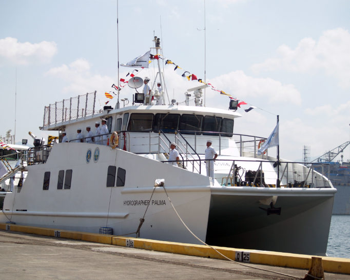
BRP Hydrographer Palma. Catamaran type survey vessel of NAMRIA-HB commissioned into service in 2015.
Why are most national hydrographic offices under the navy of their Government? The history of the IHO traces its roots to the navy. After the World War I, it was the navies of the French and British that suggested the establishment of an international bureau for hydrography. The Navy is concerned with the defense of its State. It is logical that the Navy should have the information first about their waters before anyone else.
What are the pros and cons if the Hydrography Branch of the Philippines will be transferred to the Philippine Navy or the Philippine Coast Guard? Putting the Hydrography Branch (HB) under the Philippine Navy (PN) ensures that the hydrographic information is primarily under the control of our self-defense agencies before anyone else. National security is the government’s utmost concern. Recently, there has been news that the PN is planning to acquire submarines. It is now more important that the PN have easier and greater access to hydrographic information, which is valuable to the success of any submarine warfare. The Naval Meteorological and Oceanographic Center (NAVMETOC) of the PN, which should conduct hydrographic services for the AFP does not yet have the needed resources and expertise as the HB does. The PN can surely strengthen the NAVMETOC. However, when it is fully capable of performing hydrographic services, it would also mean duplication of effort. The requirements of the armed forces, both here and abroad, are usually more stringent than civilian requirements. Hence, when the NAVMETOC serves the requirements of the AFP, it would also generally meet the requirements of the IHO. On the other hand, if the HB satisfies the standards of the civilian users, it does not necessarily mean it satisfies the standards of the armed forces.
How about transferring HB to the Philippine Coast Guard? The mandate of national hydrographic offices is to ensure safety of navigation through reliable hydrographic information. This information is disseminated through the nautical charts and publications. The mandate of the Philippine Coast Guard (PCG) is search and rescue. It is undeniable that the mandates of both HB and PCG are intertwined. Many times, the HB has been asked to support activities of the PCG in search and retrieval operations such as the SOLAR I incident in Iloilo Strait in 2006, and the MV Starlite Atlantic in 2016. The HB successfully located the locations of the sunken vessels for the PCG to conduct their operations. As of the moment, the PCG does not have equipment similar to the HB. With several maritime accidents happening within Philippine waters yearly, it might be worthwhile to consider putting the HB under the PCG similar to Japan’s JHOD under the JCG. Having HB would be complementary to PCG operations.
There are also other options for the reorganization of the HB. The important thing is the HB should be able to address the present needs of the Government and its international obligations. The priorities of the State change from time to time. Hence, structures of Government offices should also adapt. The years ahead will surely be challenging to the Philippines. Human activities have shifted and much has moved to the oceans for food, transportation and even energy. The waters of the Philippines Archipelago are much larger than its terrestrial area and with over 7,000 islands, the Navy and the Coast Guard has a lot of islands and waters to guard and protect. The geographical location of the Philippines also makes it an important route for marine transportation. Add also to this the growing concern over the West Philippine Sea. In short, hydrographic information has become more important than ever whether in defense or in commercial purposes. It is about time we evaluate the structure of our hydrographic office considering the archipelagic nature of the Philippines.
They say you have to look at the sea to look into the future. Sooner or later, our energy, food and other needs will mainly be coming from the sea. This is the right time that we strengthen our national hydrographic office in order to secure our future.
About the Author:
Commander Carter Luma-ang is currently the Chief of the Maritime Affairs Division of the Hydrography Branch.