In three separate incidents in the months of March and April, Chinese law enforcement vessels have challenged marine research and hydrocarbon exploration activities within the Philippine exclusive economic zone in the South China Sea.
Round One: China Squares off with Taiwan and Philippines over Marine Research
The Legend, a research vessel belonging to the Taiwan Ocean Research Institute under the Ministry of Science and Technology, set off from Taiwan on March 13 sailing toward the Philippines. The Legend’s schedule shows that it was booked to conduct research in the Philippines as part of Taiwan’s New Southbound Policy, an initiative of President Tsai Ing-wen to enhance relations with South and Southeast Asian countries. According to the Associated Press, the research trip was part of a joint project of the National Institute of Geological Sciences at the University of the Philippines and National Central University in Taiwan that aims to map geologic features that could trigger earthquakes, tsunamis, and other potentially catastrophic phenomena.
On March 15, Automatic Identification System (AIS) data from Marine Traffic shows the Legend began to conduct hydrographic surveys along a 50-nautical-mile wide grid to the northwest of the Philippine Babuyan Islands. On March 23, as Legend continued research 60 nautical miles NW of Luzon, China Coast Guard (CCG) 5203 left Mischief Reef in the Spratly islands. It began shadowing Legend at a distance of 2-3 nautical miles the next day. Taipei responded on March 25 by dispatching its own Coast Guard (CG) 5001 Chiayi, a 125-meter heavy patrol vessel, from Taiwan-occupied Pratas Island. The CG 5001 maneuvered to keep the CCG 5203 away from Legend in the next 2 days, with the opposing coast guard vessels in some instances coming within 1000 meters of each other.
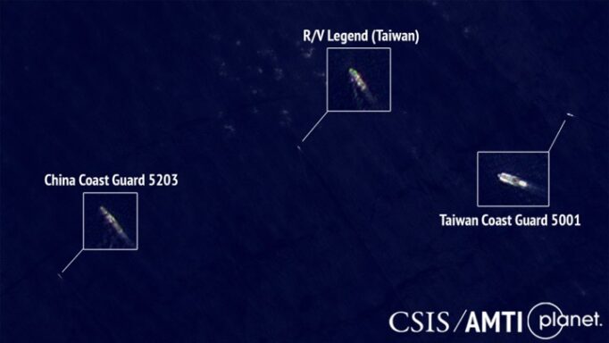
The CCG 5203, CG 5001, and Legend on March 26.
On March 27, the 60-meter CG 117 Taichung relieved the CG 5001, staying until March 30 when it was itself relieved by the 120-meter CG 129 Kaohsiung. On April 1, AIS data shows the Legend moved closer to the Philippine coast and the CCG 5203 left, heading for disputed Scarborough Shoal where China maintains a constant coast guard presence. On April 6 the Legend again moved farther offshore, operating 70 nautical miles west of Luzon. This time it was accompanied by a Philippine Coast Guard patrol vessel, the 45-meter BRP Capones. The CCG 5203 returned that same night to again shadow the Legend with BRP Capones providing protection.
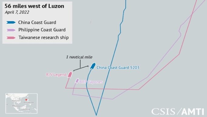
AIS tracks the Legend, BRP Capones, and CCG 5203 on April 7.
Late on April 7, BRP Capones returned to port in San Fernando, Philippines, while the CCG 5203 continued tailing the Legend. The game of cat and mouse ended on April 9 when the Legend returned to Taiwan.
Round 2: The Geo Coral and the End of Philippine Exploration
Further south along the Philippine coast, another situation was developing. Events this time centered around the Geo Coral, a survey ship owned by Norwegian seismic exploration company, Shearwater GeoServices. AIS data shows the Geo Coral arrived in Block SC 75, just 60 nautical miles off the Philippine coast west of Palawan, on April 4 where it met up with supply ship Mariska G.
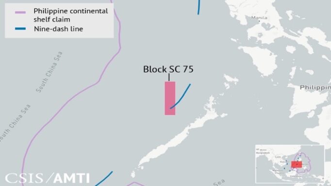
As reported by the maritime observer Duan Dang, the Philippine PXP Energy in February announced plans to conduct 3D seismic surveys in SC 75. It also planned to drill two appraisal wells in SC 72 in Reed Bank, an underwater feature claimed by China but which a 2016 arbitral ruling determined is part of the Philippine continental shelf. Soon as the Geo Coral and Mariska G arrived in SC 75, they picked up a tail: CCG 4201.
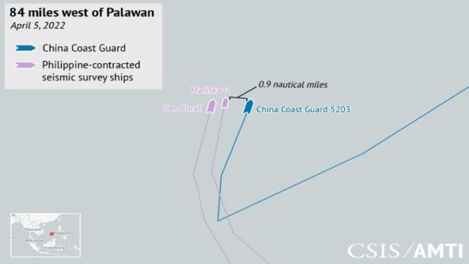
AIS tracks of Geo Coral and its supply ship Mariska G tailed by the CCG 4201
CCG 4201 closely followed the two vessels for the next two days until, on April 6, the Philippine Department of Energy ordered PXP Energy to “put on hold all exploration activities for SC 75 and SC 72 until such time that the SJPCC [Security, Justice and Peace Coordinating Cluster, part of the president’s Cabinet] has issued the necessary clearance to proceed.” The Geo Coral and Mariska G abruptly left SC-75, spending the next four days surveying closer to shore in block SC 54 before leaving Philippine waters en route to their next contract in South Korea.
Round 3: Philippine Vessels Met by CCG, Militia at Second Thomas Shoal
A few weeks later, Chinese law enforcement and militia ships again interfered with Philippine research activity, this time conducted by the M/V DA-BFAR, a 60-meter research vessel operated by the Department of Agriculture’s Bureau of Fisheries and Aquatic Resources (DA-BFAR).
DA-BFAR sailed from Palawan on April 20 heading for Second Thomas Shoal. That underwater feature is occupied by the Philippines and was ruled part of the Philippine EEZ and continental shelf in 2016. As it approached the shoal on April 21, the DA-BFAR drew the attention of CCG 5304. AIS data indicates that the 5304 pursued the DA-BFAR at extremely close distances, coming as close as 100 meters in multiple instances.
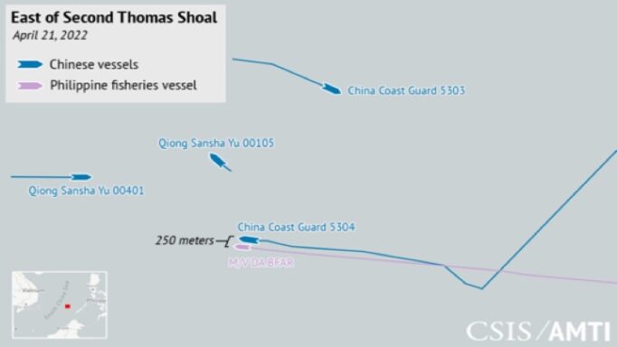
AIS tracks M/V DA-BFAR and CCG 5304 maneuvering at close range on April 21.
As CCG 5304 pursued, CCG 5303 and two Hainan-based militia vessels, Qiong Sansha Yu 00401 and Qiong Sansha Yu 00105, closed in from the north. Under pressure, M/V DA-BFAR turned around 12.7 nautical miles from Second Thomas Shoal. It retreated 13 nautical miles east before heading north toward Philippine-occupied Nanshan (Lawak), tailed by CCG 5304.
Meanwhile, a 44.5-meter Parola-class patrol vessel of the Philippine Coast Guard, the BRP Cape Engaño, approached Second Thomas from the east, having left Palawan earlier that day. It was marked by the CCG 5303 and Qiong Sansha Yu 00105, which each shadowed it at distances of approximately 1 nautical mile as it headed toward Second Thomas Shoal. The three vessels stopped approximately 6 nautical miles east of the shoal and three more militia vessels began steaming up from the south: the Qiong Sansha Yu 00009, 00101, and 00110.
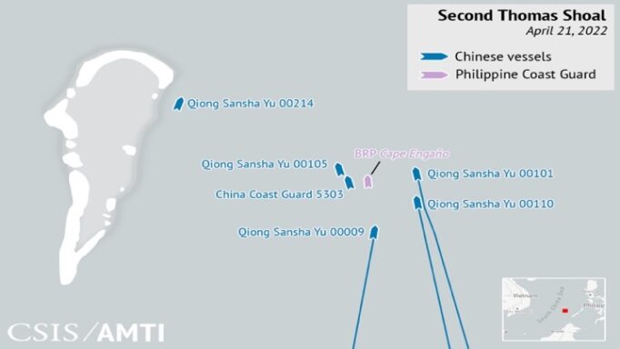
AIS tracks of the BRP Cape Engaño surrounded by Chinese coastguard and militia, April 21.
The newcomers passed less than a mile to the east of the Philippine Coast Guard ship before taking up a position at the north end of Second Thomas. The vessels all maintained their positions for several hours before the Cape Engaño turned back eastward, encouraged by the approaching CCG 5303, which tailed it until it left the area heading northwest toward the unoccupied Whitsun Reef.
An Uncertain Future
All three incidents demonstrate Beijing’s determination to control maritime activity within the nine-dash line, and to create a high risk of collisions at sea to do so. In one instance, its tactics clearly succeeded, convincing the Philippines to backpedal on an October 2020 decision to lift a nearly decade-old moratorium on oil and gas exploration in areas of its continental shelf that fall within the nine-dash line. This follows a complete lack of progress on joint exploration despite a 2018 memorandum of understanding with Beijing, making it unclear whether the Philippines will ever be able to access its hydrocarbon resources at Reed Bank. On other fronts, Philippine law enforcement, Philippine Navy, and marine science actors have been stepping up their activities in the South China Sea despite an increasingly assertive China. But with a new administration taking power at the end-June-2022, it remains to be seen how forcefully the Philippines will continue to assert those rights.
Source: https://amti.csis.org/three-rounds-of-coercion-in-philippine-waters/