
As the jurisdiction to the BENHAM RISE plateau was finally given to the Philippines in 2017, unknown to many, the Philippines has an Oceanographic and Research Capability that dates back to the 1900s until the present.
In December 1900, the US Coast and Geodetic Survey (USCGS) sent personnel to Manila to establish the sub-office of the USCGS in the Philippines. In 1901, the USCGS took over the job of map making in the Philippines but it was on 06-September-1901 when Act 222 was issued that the Philippine Government had its first official survey office established. The Bureau of Coast and Geodetic Survey (BCGS) was one of the first bureaus created by the US Philippines Commission thru Act 222. It was under the executive control of the Department of Commerce and Police. The BCGS was later renamed Philippine Coast and Geodetic Survey, then reverted back to BCGS, and then renamed several times afterwards!
It was under American Supervision until World War II, as survey ships were incorporated into the U.S. Army Transportation Corps (USATC) and into the OFFSHORE PATROL RESERVE (forerunner of the Philippine Navy Reserve Force) which also includes the 44-Ship fleet of the then Philippine Coast Guard.
These ships along with our Three Torpedo Boats showed their prowess in sea warfare against the invading Japanese Forces. After the war, The United States Army assisted in re-establishing the Coast & Geodetic Survey with its First Filipino Director CAPT ANDRES HIZON taking command.
The country’s Oceanographic Fleet consists of 13 Surface vessels that provide Marine Science and Applied Research Capability. Apart from their primary functions, they support the Country’s national sovereignty through the technical data they provide and produce such as navigational charts, maps, hydrographic surveys, checks on buoys and tides, topographic mapping, and magnetic and oceanographic surveys.
The Philippine Navy, Department of Agriculture-BFAR, and Department of Environment and Natural Resources, and National Mapping and Resource Information Authority (NAMRIA) are the agencies that possess these vessels.
Academic Institutions, such as the University of the Philippines-Visayas, also have a number of Oceanographic and Survey vessels in their fleet.
One of our earliest Research and Survey Vessels is the RPS/BRP ATYIMBA (IMO NO.6913948) built and acquired in 1969; she had a Gross Tonnage of 680 tons. She was followed by RPS/BRP ARLUNYA and RPS/BRP ARINYA. The Three ships are under the Bureau of Coast and Geodetic Survey (BCGS), which was later merged with two other agencies and became NAMRIA. They were augmented by another BFAR Research Vessel, the 419-ton RPS Researcher acquired in 1966.
On 21-February-1984, the mines and geosciences bureau acquired the 697-ton RPS Explorer with President Ferdinand Marcos accepting the vessel from the Japanese Government.
In 1993, The Philippine Navy acquired 2 Intelligence Research Vessels BRP Fort San Antonio (AGS-700) and BRP Fort Abad (AGS-701), both vessels still in active service, while in 1998 NAMRIA acquired from Spain the 1,170 tons each BRP Hydrographer Presbitero and in 1999 BRP Hydrographer Ventura, making them the largest Oceanographic vessels in our fleet until the arrival of BRP Gregorio Velasquez (AGR-702) in April 2016. They were named after key Officers of the agency during their early days, CAPT Jayme V Presbitero and CAPT Antonio P Ventura.
On the other hand, and third largest vessel in our Oceanographic fleet is the Department of Agriculture’s-BFAR MV DA-BFAR a 1,156-ton ORV; she is 8 meters longer than the 2 NAMRIA vessels.
In June 2015, the NAMRIA fleet was boosted with the commissioning of the two modern Catamaran type Hydrographic Vessels, namely BRP Hydrographer CAPT ANDRES HIZON, and BRP Hydrographer COMMODORE CAYETANO PALMA. These ships are capable of 10 to 3,000 meters depth surveys with complete state-of-the-art navigation and hydrographic research systems. Even during their commissioning, the vessels were being eyed to conduct surveys on the Philippine Rise (BENHAM RISE).
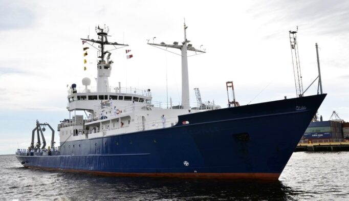
BRP Gregorio Velasquez (AGR-702) from Philippine Navy Facebook Page (Official Philippine Navy Photograph).
The largest vessel in our IOR Fleet is the former 2,516-ton RV Melville of the Scripps Institution of Oceanography; she was acquired by the USN on 01-August-1969 as the USNS Melville (T-AGOR-14). She was named after the arctic explorer RADM George Wallace Melville USN. Upon transfer to the Philippine Navy, she was renamed BRP Gregorio Velasquez (AGR-702), after a famous Filipino National Scientist known for his works in the field of Phycology, the study of algae.
Our Oceanographic capability is furthered by civilian or academically manned specialized vessels such as the UP-Visayas MV Pampano acquired from Japan in 1962 followed by MV Albacore in 1972. In 1981, a Japanese donated a 481-ton Research vessel that added to the UP fleet, and was christened RV Sardinella.
Dedicated units and agencies in the field of Oceanography exist in the Philippine Navy and the Academe as characterized by the Former Ocean and Littoral Affairs Group (OLAG), now the Naval Meteorological and Oceanographic Center (NAVMETOC), NAMRIA’s National Coast Data Center, and the University of the Philippines Marine Institute (UP-MSI).
In this brief article, I have highlighted our Research and Oceanographic vessels, I have touched lightly on their capabilities and equipment for security reasons, though each vessel has its own specialized function that could augment each other and are well capable of conducting surveys in support of our FOREIGN POLICY and NATIONAL SOVEREIGNTY, and it is worth noting that right from the start it was the UNITED STATES that assisted us in developing and establishing our Oceanographic Capability.
SOURCES:
- Cdr. Carter Luma-Ang, NAMRIA
- http://www.gov.ph/…/letter-of-implementation-no-19-s-1972/
- https://www.scribd.com/doc/217898174/Hydrographic-Surveying
- http://www.namria.gov.ph/
- https://upvcfos.wordpress.com/36-2/
- http://www.ships.lv/en/vessels/6913948-atyimba.html,
- https://journals.lib.unb.ca/…/article/download/23010/26707
- http://megaslides.com/…/presentation–ppt-1.3mb…
- http://philippinenavy.tripod.com/oceano.html
- http://www.gov.ph/…/address-of-president-marcos-at-the…/
- https://en.wikipedia.org/wiki/George_W._Melville
- http://www.businessmirror.com.ph/2-namria-survey-ships…/
- http://www.manilatimes.net/bfar-starts…/241864/
- http://arcoastnews.tripod.com/issue2/htmls/optimizing.htm
PHOTO SOURCES:
- http://www.artfreaks.com/forums/index.php?/gallery/image/1531-rps-explorer-alongside-in-subic-bay-001jpg/&browse=1
- http://www.nauticexpo.com/…/product-31064-194390.html
- http://ship-photo-roster.com/…/brp-hydrographer-presbitero
- http://www.shipspotting.com/gallery/photo.php?lid=1399
- https://www.flickr.com/photos/mcgutib/6289066326
- http://images.gmanews.tv/down…/dreamcruise2013/12_0011.jpg
About the Author:
CDR Mark R Condeno is Deputy Administrative Officer, Philippine Korean Friendship Center and Museum Curator, PEFTOK Korean War Memorial Hall Museum under the Dept of National Defense-Philippine Veterans Affairs Office. In 2007, he was Research Officer at the Office of the Naval Historian, PN; and Projects Officer at the Maritime Historical Branch of the Fleet-Marine Warfare Center, PN. He earned a BS Architecture at Palawan State University. In 1997, he completed the Basic Naval Reserve Officers Training Course, PN; and is with Bravo Class of 1999, PCG Auxiliary Officer’s Indoctrination Course. In 2002, he took the Aerospace Power Course at Air University, USAF. In 2008, he took the Military History Operations Course at U.S. Defense Technical Information Center. He is with Class 26 of Executive Course on National Security, at the National Defense College of the Philippines. He has been published in PAF Review, PAF Perspective, PN Journal, PN Digest, Rough Deck Log, CITEMAR6, USNI Proceedings, Asiaweek, USAF Air & Space Power Journal, and CIMSEC.