The Port of Cagayan de Oro is situated in Cagayan de Oro City, the capital of Misamis Oriental and the regional center of Northern Mindanao. It is located in the Northern Coast of Mindanao within Macajalar Bay, near the mouth of the Cagayan de Oro River. It faces northwest and is protected to the east by a stretch of coast running almost due north for nearly 30 kilometers. A highway links Cagayan de Oro with Iligan, Butuan and Davao.
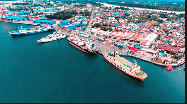
The Port of Cagayan de Oro, an international seaport in Mindanao, is the most modern outside Metro Manila. The seabed off the port is steep and reaches 1,000 meters deep at the entrance of the Macajalar Bay, which has a wide mouth. Anchorage is ideal for transnational vessels with a depth of 18 meters, and is approximately 400 meters from the shoreline. The depth of safe anchorage is 60 fathoms. It has 14 berthing areas with varying drafts from 8-13 meters, totaling 954 meters, 1 RORO ramp, two 50-ton weighbridges, 126 reefer outlets, 2 hectares of open storage areas, and a 5,500 sqm container freight station. The port serves 14 domestic and 4 foreign shipping lines.
The Port Management Office (PMO) of Cagayan de Oro has 3 Terminal Management Offices (TMO): TMO BALINGOAN; TMO CAMIGUIN; and TMO OPOL, all of which have RORO.
The Internet-Based Port Operations and Receipting for Terminals Systems (iPORTS), a system developed to convert Non-computerized Ports (NCP) to computerized operations, was successfully rolled out at the TMOs under the PMO of Misamis Oriental/Cagayan de Oro (MO/CDO) in October 2018. The iPORTS will be rolled out in the Base Port in 2019.
There are 6 public ports in Cagayan de Oro, namely: Balbagon, Guinsiliban, Medina, Molugan, Cugman, and Kimaya; and 9 private ports in the PMO, namely: CDO Oil Co; Resin Inc.; San Miguel Corp.; Cagayan Corn Products Corp.; Pryce Gases Inc.; Holcim Philippines; General Milling Corp.; Siddharta Holdings Co, Inc.; and Minergy Power Corp.
The Port of Cagayan de Oro is the busiest government port in Northern Mindanao in terms of cargo throughput. Dubbed as the Global Gateway to Mindanao, its strategic location makes it the entry and exit point of goods and passengers for the city of Cagayan de Oro and the provinces of Misamis Oriental, Camiguin, Agusan, Bukidnon, and Davao. In 2017, total cargo throughput reached 9.5M MT, of which breakbulk was 2.45M MT, dry bulk was 1.755M MT, liquid bulk was 1.648M MT, and containerized cargo was 3.647M MT.
The Port of Cagayan de Oro is classified as a Class A general cargo port that caters to practically all sorts of goods including agricultural products, industrial products, bottled products and canned goods, chemicals and petrochemicals. The Port is part of the Central Nautical Highway under the RORO (Roll-On Roll-Off) Transport System linking Mindanao to Cebu, Iloilo, Bacolod, Jagna and Tagbilaran in Visayas, and Manila and Batangas in Luzon.
The Port of Cagayan de Oro is an ISO 9001:2008 certified port as to the facilitation of vessel entrance and clearance processes. It is also recognized by the Partnerships in Environmental Management for the Seas of East Asia (PEMSEA) for its implementation of the Port Safety, Health and Environmental Management System (PSHEMS) which covers three standards: ISO 9001:2008 (Quality Management), ISO 14001:2004 (Environmental Management) and OHSAS 18001:2007 (Occupational Safety and Health). The Port is compliant with the International Ship and Port Facility Security (ISPS) Code.
Former President Gloria Macapagal-Arroyo issued Executive Order 769 on 19 November 2008 declaring and delineating the Cagayan de Oro Port Zone under the administrative jurisdiction of the Philippine Ports Authority (PPA). The Cagayan de Oro Port Zone has a total area of 364 hectares, composed of a land area of about 25 hectares, and sea area of 340 hectares. The range of mountains protecting Macajalar Bay rises to 2,560 meters above mean sea level and to the south by the Kitanglad mountains up to 2,900 meters high. The Cagayan River flows down between the Kitanglad and Mapoto mountains in a steep-sided valley, disgorging into the south side of Macajalar Bay through a wide alluvial plain. The headland to the east of the river mouth, Macabalan Point, protects the smaller inner bay. Cagayan de Oro City is established on the east bank of the river.
Over the years, the Port of Cagayan de Oro has spurred the economic development of Northern Mindanao. Since 2010, the Philippines has enjoyed a satisfactory performance in terms of GDP, with a growth rate in 2017 of 6.7% (World Bank), while Northern Mindanao registered 5.9% (Philippine Information Agency). This economic upswing is projected to continually go up as more road networks and bridges now connect the Port of Cagayan de Oro to major cities in Mindanao, such as the coastal road which offers an alternate link to Bukidnon and Opol, Misamis Oriental.
The Department of Transportation (DOTr) announced in early September this year that the Port of Cagayan de Oro’s new passenger terminal building is 79% complete. It is scheduled to open and be fully operational by December. The Port of Cagayan de Oro is set to be the biggest port passenger terminal building in the Philippines, and is expected to accommodate around 3,000 passengers daily.