INTRODUCTION
This article is a research on sea state conditions and the Beaufort scale –how sea state conditions can affect ship operation at sea and how the Beaufort scale can be a tool of information to define the characteristics of waves and its effects on ship navigation.
WAVE GEOMETRY
The forces generated by ocean waves are among the most powerful naturally occurring forces on earth. In order to better understand the effects of ocean waves on ship stability, we need to study the wave phenomenon itself. Oceanography is a vast and complex science. A comprehensive study of Oceanography is well beyond the scope of this research work. Therefore, in this article we will confine our discussion to just a basic introduction on the ocean wave phenomenon.
Fig. 1
Theoretical Wave Form
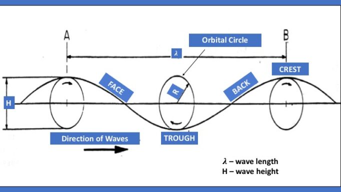
Wave forms resemble certain mathematical curves but do not correspond exactly to these curves.
In theory, deep water surface waves are formed by water particles moving in circular orbits about their centers of rotation. This is depicted in Figure 1. While a water particle makes one complete orbit, the crest of the wave shifts from position A to position B. The distance from point A to point B is known as the wave length . The time it takes for the crest to shift from point A to point B is called the wave period (T). The wave height (H) is equal to the diameter (2R) of an orbit.
WAVE HEIGHT is the vertical distance between the trough and the crest. Wave heights vary in magnitude from about 0.02 ft. in ripples to over 100 ft. in ocean storms. However, about 95% of all waves have heights below 16.5 ft. (5m) and the most frequently observed waves at sea are about 5 ft. (1.5m) high.
WAVELENGTH is defined as the distance between adjacent wave crests. Wavelengths vary from 0.55 ft. (1.7 cm) in ripples to about a mile (1.6 km), and even greater distances where seismic disturbances are involved.
The WAVE PERIOD is the time that passes between the arrival of the centers of two consecutive wave crests at a fixed point. Most wave periods range between 5 seconds and 50 seconds. Very much longer periods, (1,000 seconds – 10,000 seconds) are associated with earthquakes and tidal waves. Most storm waves have periods ranging between 12 and 15 seconds while a commonly occurring “Atlantic” wave has a period of 6 to 9 seconds.
Waves with periods of up to 2 seconds are known as ripples; from 2 to 5 seconds are called a chop; from 5 to 15 seconds a sea; and from 15 to 30 seconds, a swell.
STEEPNESS is defined as the ratio of wave height to wavelength (H/). This is an indication of the surface slope of the wave. For ratios much less than 1:7 (0.14) wave surfaces tend to have smooth curves (sinusoidal wave form). For values that approach 1:7, crests become sharper while troughs remain smooth (trochoidal wave form). At the critical value of 1:7, waves become unstable and break. Large breaking waves are very dangerous.
WAVE SPEED. This is the velocity at which the wave crest moves. It is dependent on the wave length and depth above the sea bottom and can vary between 0.5 knots for ripples to over 400 knots for waves in mid ocean earthquakes.
ORIGIN OF WAVES. Ocean waves are caused primarily by the transfer of kinetic energy to water from the wind. The wind energy, passing over the ocean surface sets small particles of water in motion. These particles accumulate along closely spaced surface ridges, producing small wavelets (ripples). High pressure on the windward surface of each wavelet results in further depression of the water on that side of the wavelet. Lower pressure on the leeward side causes further elevation on that side. As the wind continues to supply energy to the water, the wave continues to grow in height and length until any excess energy is dissipated by internal friction in the water. The rate at which the wave grows depends on the difference between the wind velocity and the wave velocity. A sudden increase in wind velocity can cause a rapid build-up in wave height at a rate of as much as one to two feet per minute.
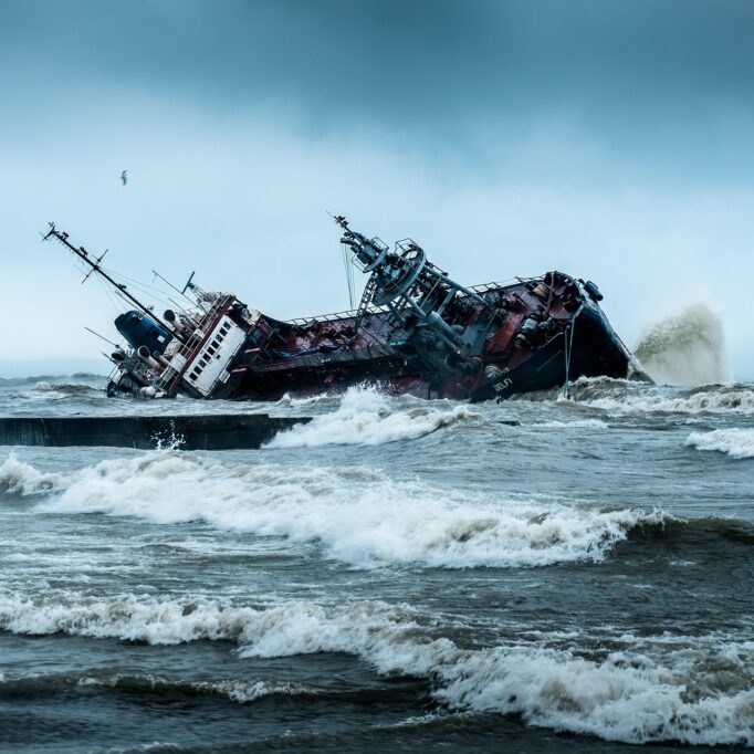
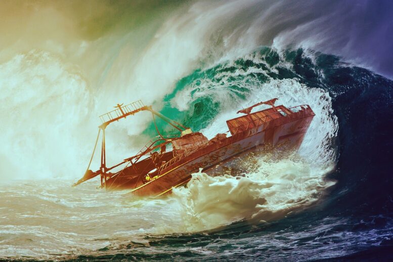
BREAKING WAVES. Waves will become unstable and break when the ratio of wave height to wavelength exceeds 1:7 (0.14). Reduced local gravity at the crest combined with high wind drag, causes the top third of the wave to detach and come thundering down with a turbulent and random motion. Never get caught abeam on a large breaking wave.
DEFINITION OF SEA STATE CONDITION
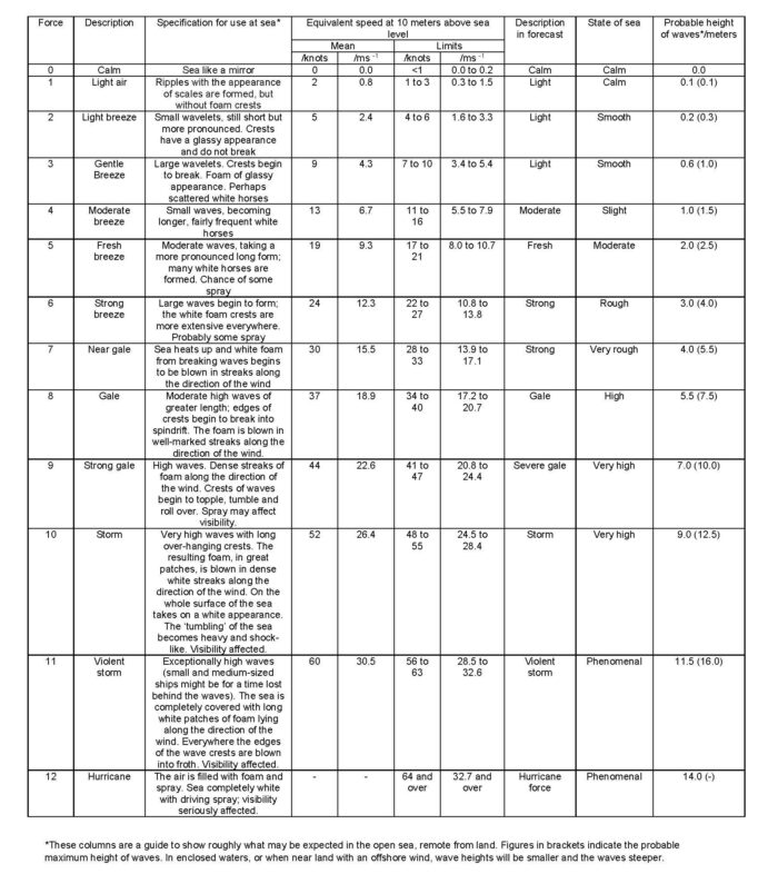
Table 1.
(Source: www.clubcruceros.net/CruisingBaja/Beaufort.html)
PHILIPPINE SEA AREAS OF RESPOSIBILITY
Figure 1
Philippine Areas of Responsibility
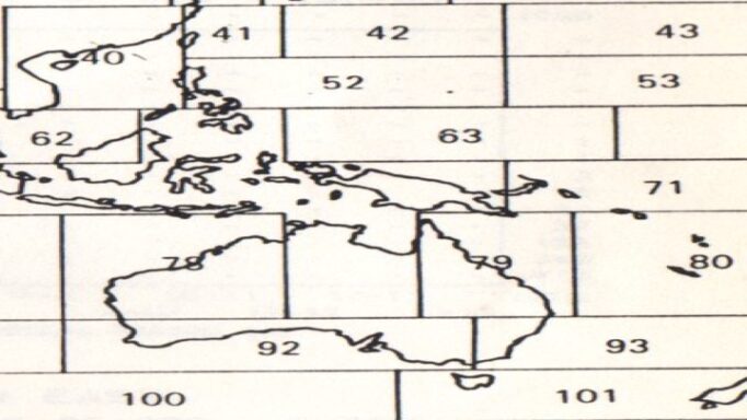
Photo Credit: World Meteorological Organization.
THE WAVE ENVIRONMENT. The Philippines lies on the boundary between “Global Wave Statistics” Area 40 (105-120o E, 10-30oN) and Area 52 (120-150oE, 10-20oN). In these two areas significant wave heights exceed 4 meters less than 11% of the time, therefore the operability of the surface ship will hardly be affected by the weather. (World Meteorological Organization – WMO)
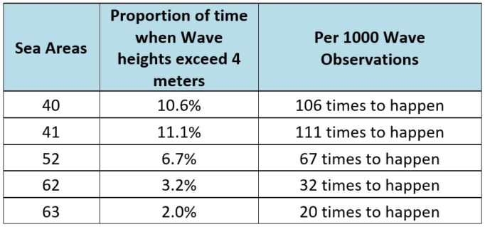
PROBABILITY OF SEA STATE 6 CONDITION OCCURRENCE OF FULLY ARISEN SEAS
Table 2.
Philippine Sea Condition, Sea Area 40,
Sea Area 41 and Sea Area 52
Sea State – is the description of a wave characteristic and how it appears in the open ocean.
Beaufort Scale – is the measure of wind velocity that triggers the ocean waves, as the wind velocity collides with the surface of the ocean.
WAVE LENGTH/SHIP LENGTH
A ship whose length waterline is equal to the wave length, and wave height is less than the freeboard, will only experience less severe functionality degradation in rough seas (pounding, slamming, wetness of the deck, excessive rolling and pitching, emergence of propeller at the surface, etc.), whereas a ship whose length waterline is smaller than wave length, and wave height exceeds the freeboard will encounter severe functionality degradation of the ship’s system in rough sea conditions. Both conditions are presumed to be at head-on seas. The ship faces a risky heading if she exposes the ship broadside against the waves.
RECOMMENDATION
As a basic rule, the skipper’s real time observations on the prevailing sea condition must employ all his due diligence to avoid being caught by rough sea condition, or in case of being caught and encountering such rough sea condition in the middle of the ocean, always bring the ship to face head-on seas rather than exposing the ship broadside, a dangerous ship position in relation to the kinetic energy of the waves being absorbed by the hull of the ship at beam seas.
REFERENCES
- The Armchair Sailor, Books and Chants 543 Thomas Street, Newport, Rhode Island 02 240
- Technical Evaluation Summary on Maritime Safety Capability Improvement Phase II for PCG Ship Acquisition Program
- Global Wave Statistics, World Meteorological Observation (WMO)
- Edward Lewis, Principles of Naval Architecture
- Definition of Sea State Condition of Fully Arisen Seas, clubcruceros.net/CruisingBaja/Beaufort.html
ABOUT THE RESEARCHER
CAPT TOMAS D BAINO PN (Ret), a retired naval officer in 2004 and was former Commander of the Naval Research and Development Center, Naval Sea System Command of the Philippine Navy. He has undergone orientation seminars in Hydrodynamics laboratory in the UK Defense Evaluation Research Agency (DERA), under the sponsorship of UK Ministry of Defense, England in 1998. He served as Naval Architect Ship Acquisition Consultant with PCG/DOTr for 3 years, from 2017 to 2020.